Nationwide parcel data can span all 50 U.S. states without coming from a single federally maintained parcel database, as the FGDC cadastral program makes clear. For product and underwriting teams, that distinction matters: national coverage describes geographic reach, not uniform freshness, complete attributes, or survey-grade boundaries. Evaluate the dataset as a governed collection of local records, not just a map.
- Coverage: Confirm which jurisdictions and property types are represented.
- Currency: Separate the age of ownership information from the age of boundary geometry.
- Fitness: Match source confidence to the decision, especially before funding or approving site work.
- Access: Preserve identifiers, timestamps, and provenance through every API response or bulk export.
A useful evaluation starts with what a parcel represents, then tests whether its records can support your actual decisions.
What Does Nationwide Parcel Data Actually Cover?
Nationwide parcel data is a national collection of land parcel boundaries and property attributes assembled from county and state records, rather than one federal database. Its value comes from connecting records that local authorities maintain differently into a structure analysts can query consistently.
The Federal Geographic Data Committee's Cadastral Data Content Standard, first published in December 1996, defines a parcel as a single cadastral unit representing the spatial extent of past, present, and future rights and interests in real property. That definition is broader than a colored tax-map polygon. It includes the property interests associated with a location, not merely its visible outline.
The standard works like a shared address format for land records, not a single post office that delivers every letter. It establishes common information for discovering records, identifying their maintainers, and understanding access.
Practical distinction: A common data model makes local records exchangeable. It doesn't make local maintenance practices identical.
Connected property records
A usable national record connects spatial extent with the information needed to interpret it.
| Component | What it tells an analyst | What to verify |
|---|---|---|
| Spatial extent | Where the parcel is represented | Geometry source and intended use |
| Ownership or rights | Which recorded interests attach to it | Source authority and effective date |
| Assessment | How the assessor describes its taxable value | Assessment period and field meaning |
| Source agency | Who maintains the underlying record | Jurisdiction and source identifier |
| Access metadata | How the record can be obtained | Delivery method and restrictions |
The national framework includes onshore and marine cadastral information. That scope doesn't mean every commercial dataset includes every category of property interest or offshore record.
For evaluation, separate field availability, geometry and freshness confidence, and access conditions. A dataset can perform well on one dimension and poorly on another. A detailed property profile is still unsuitable for a boundary-sensitive decision if its geometry lacks documented accuracy.
Which Fields Does a Parcel Record Contain?
A nationwide parcel record typically combines identity, geography, ownership, valuation, property characteristics, and update metadata, but field population must be checked locally. Use this schema as an evaluation checklist, not a promise that every jurisdiction supplies every attribute.
Core fields in a nationwide parcel record
| Field | What it holds | Why it matters |
|---|---|---|
| Parcel number (APN) | County-assigned identifier with a county-specific format | Join key that needs jurisdictional context |
| Situs address | Physical street address associated with the parcel | Primary candidate for property-level matching |
| Mailing address | Address used for tax correspondence | Supports owner correspondence and absentee-owner analysis |
| Geometry | Polygon boundary in a stated coordinate reference system | Supports area, overlap, and preliminary setback checks |
| Latitude and longitude | Representative parcel coordinates, often a centroid | Supports map placement and radius searches |
| County, ZIP and school district | Administrative and service geography | Groups properties for market and boundary analysis |
| Owner of record and vesting | Recorded name and manner of holding ownership | Supports ownership, lien, and pre-foreclosure research |
| Legal description | Property description from recorded documents | Supports title review and deed matching |
| Assessed value and tax | Assessor valuation and tax information | Supplies valuation-model inputs and tax context |
| Lot size and zoning | Land area and zoning classification | Screens development feasibility and potential use |
| Building characteristics | Bedrooms, bathrooms, floor area, and construction details | Supports property modeling; check completeness outside metros |
| Last-updated date | Record, attribute, or layer refresh timestamp | Makes currency assessable when timestamp meaning is documented |
Identity and address matching
A normalized parcel key should combine jurisdiction with the source parcel identifier. An APN isn't a nationally unique property identity, and removing punctuation or leading zeros without understanding the county format can create collisions.
The distinction between an identifier and an address is explained in this guide to APNs in real estate. Treat address matching as a reconciliation step, not a substitute for a durable key.
A situs address locates the property. A mailing address locates the recipient of tax correspondence, who may live elsewhere or use a business address. Joining ownership records to parcel locations using mailing addresses can attach the wrong property to an owner's residence or office.
Field interpretation
A field name doesn't establish a field's analytical meaning. Assessed value isn't automatically market value, a zoning label doesn't establish development approval, and centroid coordinates don't identify a driveway or legal access point.
The FGDC relational cadastral standard describes parcel-to-boundary relationships as many-to-many. Retain stable parcel and boundary identifiers, relationship tables, lineage, and historical versions rather than assuming each legal parcel always maps cleanly to a single current polygon.
Finally, require a last-updated field with a definition. A recent export timestamp only proves that someone exported the record recently. It doesn't establish when the county last changed the ownership, assessment, or boundary.
Where Do Parcel Records Come From and How Current Are They?
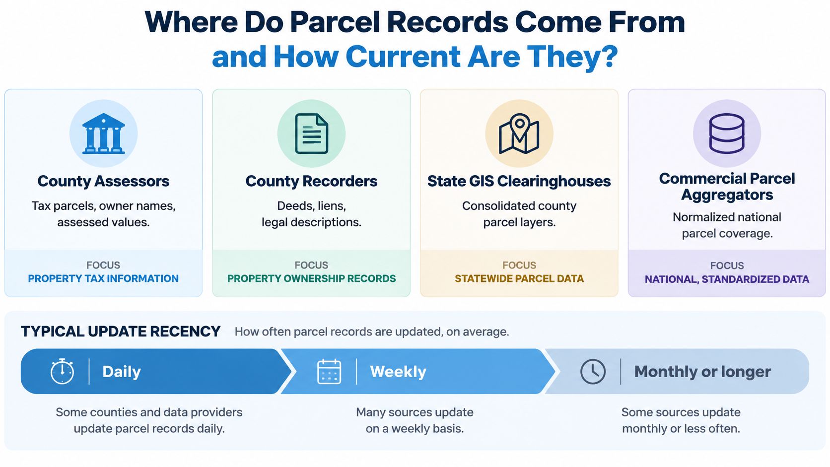
Parcel records originate with assessors, recorders, and other local authorities, then reach national users through state consolidation and commercial aggregation. Coverage measures whether records exist across geography; freshness measures whether those records still describe the property you're evaluating.
These source types serve different functions. Don't treat a federal framework, a recorded deed, and an aggregator's normalized property record as interchangeable evidence.
Parcel data source types and their limits
| Source type | Examples | What it supplies | Main limitation |
|---|---|---|---|
| County assessor | County assessor offices | Tax parcels, owner names, assessed value | Formats and fields differ by county |
| County recorder | County recorder offices | Deeds, liens, legal descriptions | Recording can lag the transaction |
| State GIS clearinghouse | State parcel viewers and portals | Consolidated county layers | Participation and completeness differ across states |
| Federal national layer | USDA national parcel layer | Nationwide geometry and ownership fields | Attributes don't all update together |
| Commercial aggregator | Providers such as BatchData | Standardized national schema, APIs, and bulk files | Methodology, provenance, and county coverage require evaluation |
| Federal framework | FGDC Cadastral Data Content Standard | Common definitions and attribute structure | Not a dataset; doesn't maintain local polygons |
The infographic summarizes how source records become national datasets.
Coverage is not completeness
A county can be covered even when individual parcels or attributes are missing. The USDA national parcel bulletin describes coverage of 100 percent of U.S. counties and approximately 99.8 percent of parcels, including Puerto Rico, Guam, the U.S. Virgin Islands, and the Northern Mariana Islands.
Those measures describe geographic and parcel coverage, not the completeness of zoning, building characteristics, owner names, or legal descriptions. Evaluate required attributes separately, using populated-field rates for the counties your application serves.
Our property, permit, and owner data is national. Our national property, owner, and contact data is refreshed daily. Those statements describe service area and refresh cadence, not a claim that each local authority records a new event immediately.
For source selection, the complete guide to real estate data sources helps distinguish assessment, transaction, and other property inputs. Keep those distinctions in your data dictionary instead of collapsing every incoming value into an unexplained property field.
Freshness is a distribution
National recency averages can conceal counties that are too stale for your workflow. The ReportAll year-in-review reports 159.3 million polygons, with 90 percent of counties updated within 12 months but only 70 percent within six months.
County-based freshness and parcel-based freshness answer different questions. A county statistic weights a sparsely populated jurisdiction the same as a dense one; a parcel statistic weights the property inventory. Neither tells you whether a particular collateral parcel reflects a recent split.
A smaller dataset with transparent source dates can be more useful than a larger national dataset whose record age is hidden.
Build a freshness distribution by county and attribute family. Track source-effective dates, acquisition dates, and publication dates separately. When an authority publishes no effective date, label it unknown instead of substituting your ingestion timestamp.
Ownership, geometry, and valuation also need separate histories. A transfer may appear before the next map publication, while a subdivision can require new identifiers and relationships to retired parcels. Overwriting yesterday's row destroys the evidence needed to reproduce an earlier underwriting decision.
Temporal reconciliation
Treat parcel changes as events, not just replacement rows. Preserve both the time the source says a change became effective and the time your system learned about it.
Your ingestion process should distinguish:
- Splits: Retain the retired parent identifier and links to successor parcels.
- Mergers: Preserve predecessor relationships rather than treating the combined parcel as unrelated.
- Boundary revisions: Separate shape edits from changes to ownership or legal interests.
- Corrections: Record whether a source fixed an error or documented a new event.
For implementation context, the ELECTE multi source integration guide offers a useful companion to designing source reconciliation. Apply that integration discipline to parcel lineage: retain conflicting source values long enough to investigate them, and document the rule used to select the published value.
Before accepting national coverage, require a county-level inventory that identifies missing geography, stale sources, timestamp definitions, and change-handling rules. A coverage percentage can't answer those operational questions.
Which Use Cases Need Nationwide Parcel Data?
Nationwide parcel data earns its cost when decisions span counties and depend on property boundaries, ownership, or attributes. The required evidence changes with the decision: market segmentation can tolerate approximate spatial classification, while collateral verification cannot.
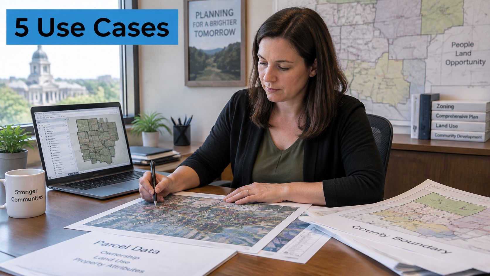
Parcel-based planning connects map analysis with property-level review.
Decision requirements
Each workflow needs a defined parcel relationship, not merely a successful address lookup.
| Use case | Analyst's task | Critical inputs |
|---|---|---|
| Underwriting | Reconcile collateral identity with recorded property evidence before funding | Parcel identifier, legal description, boundary lineage |
| Insurance | Aggregate regional exposure and review property characteristics | Correct parcel match, assessed value context, building attributes |
| Logistics | Test a depot candidate against access and routing requirements | Boundary, access evidence, road connections, site verification |
| Portfolio monitoring | Detect ownership, lien, and pre-foreclosure changes | Stable identity, event dates, ownership and recorded-document feeds |
| Marketing and lead generation | Segment properties and distinguish owner mailing locations | Situs address, mailing address, ownership classification, assessed value |
For insurance, assessed value supplies context, not a replacement-cost estimate. For logistics, a parcel polygon doesn't prove that a truck can enter from the adjacent road or that an access easement permits the planned movement.
Portfolio teams need change detection that survives identifier changes. Otherwise, a parcel split can look like an asset disappeared while its successors enter the system as unrelated properties.
This video provides additional visual context for property-data workflows.
Identity controls
Linking property facts to people requires tighter controls than displaying boundaries. Owner names, mailing addresses, phone numbers, and email addresses should have purpose-based access, audit logs, suppression handling, and documented retention rules.
For marketing execution, Helbling Digital Media's discussion of SEO and paid media for agents helps distinguish audience strategy from acquisition channels. A property segment isn't automatically a permissioned contact list.
Risk boundary: Publicly accessible property geometry doesn't establish unrestricted rights to use every identity attribute attached to it.
Among these workflows, stale county information is especially dangerous when underwriting a recently changed collateral parcel. A current-looking application paired with an obsolete boundary or legal description can cause the lender to evaluate the wrong property interest.
How Accurate Does Parcel Geometry Need to Be?
Coverage does not equal spatial accuracy, and the required accuracy must come from the decision rather than the map's appearance. A polygon that looks convincing at street scale can still be unsuitable for title, construction, or exact setback analysis.
The FGDC-endorsed accuracy framework and submission guidance calls for site-address and spatial information, geometry without gaps or overshoots, endpoint snapping within five meters, separation of distinct points, vertices, and edges by at least one meter, and positional accuracy expressed at a stated confidence level, commonly 95 percent. These are quality-control concepts, not a blanket guarantee that national assessor polygons meet a particular ground accuracy.
Geometry validation
An ingestion pipeline should test geometry before publishing it to decision systems. Use tools such as PostGIS or QGIS to inspect invalid shapes and preserve the original geometry before making repairs.
Run checks for:
- Required attributes: Confirm usable location information, source identifiers, and a declared coordinate reference system.
- Polygon validity: Detect unclosed rings, self-intersections, empty shapes, and malformed multipart objects.
- Topology: Find unexplained slivers, overlaps, gaps, and mismatched shared edges.
- Transformation errors: Check axis order, units, and coordinate transformations before comparing layers.
- Repair side effects: Flag edits that change area or boundary position beyond the source's documented tolerance.
Don't automatically snap every nearby edge. Adjacent legal interests can have meaningful differences, and an automated repair can erase valid source information.
Geometry tolerance and source confidence by use case
| Use case | Geometry tolerance needed | Source confidence required |
|---|---|---|
| Market screening and segmentation | Approximate neighborhood classification without exact edge decisions | Assessor-derived geometry with known limitations |
| Portfolio monitoring | Correct boundary associated with a persistent parcel identity | Standardized geometry with source and version tags |
| Underwriting and insurance | Boundary representation consistent with recorded property evidence | Higher-confidence geometry with stated accuracy |
| Logistics site validation | Documented edge matching plus access-specific verification | Traceable source and field or surveyed confirmation where needed |
| Setback, construction and title | Survey-grade evidence appropriate to the legal or engineering task | Surveyed boundary tied to the legal description |
Confidence and fitness
Topological cleanliness and positional accuracy are different properties. A perfectly closed polygon may be shifted from its true ground location; an accurately positioned boundary may still arrive with invalid ring structure.
The FGDC standards catalog distinguishes cadastral content definitions from the procedures and spatial linkages needed to build and maintain a GIS. Standards alignment therefore doesn't replace geometry validation, source matching, or operational quality control.
Assessor-map boundaries are useful for regional screening because the decision concerns broad spatial relationships. Construction and exact setback decisions concern the legal position of an edge, so use the appropriate survey and recorded evidence instead of measuring a web-map outline.
Store a source fitness statement, coordinate reference system, update timestamp, edge-match status, and confidence tier alongside each geometry. Expose those fields to downstream users so an application can reject unsuitable records rather than treating every polygon as equally trustworthy.
How Do You Confirm Coverage Before You Commit?
A national coverage percentage is an average, and averages hide stale counties. Treat a parcel feed as a governed time series: every record should carry a source, an export date, a geometry vintage, and a confidence tier, because a polygon that is clean enough for regional screening can still be wrong for a boundary-sensitive decision.
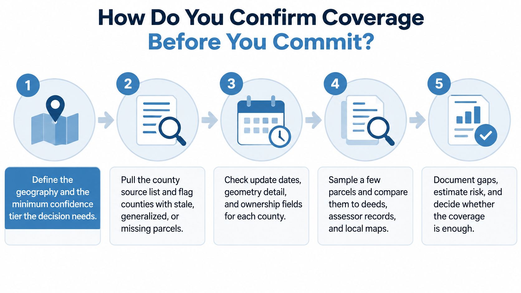
Use this acceptance process before buying a national feed or building an aggregation pipeline.
- Define geography and confidence requirements. Name the target jurisdictions and the decisions the dataset must support. Separate screening records from records eligible for boundary-sensitive review.
- Inspect the county source inventory. Flag missing parcels, generalized geometry, unknown source dates, and stale jurisdictions.
- Request a manageable cross-county sample. Compare parcel identities and geometry against county GIS viewers, assessor records, and recorded documents. Include recently changed properties so the sample tests time lag, not only static accuracy.
- Run automated QA. Validate required fields, polygon closure, overlaps, coordinate reference systems, and transformation behavior.
- Test joins using county code and parcel number. Measure unmatched and ambiguous records instead of forcing address-only matches.
- Retain decision evidence. Store source, export date, confidence tier, and the snapshot used for each consequential decision.
- Set a layer-specific refresh schedule. Write into the delivery terms which layers update daily where offered, which follow county cycles, and what happens when a jurisdiction lags.
Keep the visual as the review checklist, and keep field tolerances, CRS handling, and rejection rules in implementation documentation.
Refresh checks by parcel data layer
| Data layer | Coverage question to answer | What it means for decisions |
|---|---|---|
| Parcel geometry | Which counties changed since the last extract, and which still carry generalized boundaries | Recent subdivisions may be absent from some jurisdictions |
| Full dataset export | Whether the snapshot date and the newest source record date are the same | Reproducible batch snapshots can still contain older county inputs |
| Premium property fields | Which attributes refresh with ownership and which follow assessor or recorder cycles | Property-attribute refreshes must be evaluated separately from ownership |
| Enhanced ownership data | How often owner and contact records are published, and how much source lag remains | BatchData's national property, owner and contact data is refreshed daily; frequent publication supports transfer monitoring without proving every county source changed that day |
Access and cost
Choose access based on maintenance responsibility as well as acquisition price. Direct county downloads may be free, but availability, licensing, and formats are uneven. State clearinghouses reduce collection work; national APIs and bulk files reduce normalization work.
BatchData offers bulk data with multiple delivery methods, convenient delivery schedules, custom datasets, and flexible pricing and packaging. Use the property data coverage checker guide to structure the geographic review, then price the exact county set, attributes, update cadence, and delivery arrangement you need.
Commit only when coverage, freshness, confidence, and access meet your acceptance criteria.
BatchData offers national property, permit, and owner data, with API and bulk access for property-level workflows. Visit BatchData to discuss your target counties, required attributes, and delivery needs, and use a representative sample to validate fitness before integrating nationwide parcel data into production.