The United States had approximately 150 million land parcels in the Federal Geographic Data Committee's 2009 annual report, but those parcels weren't maintained as one national database. That distinction still shapes how you should evaluate county parcel data: a usable file isn't necessarily a complete, current, or decision-ready dataset. Judge each field and boundary by the decision it supports, not by whether it opens in a GIS viewer.
- Coverage: Establish which jurisdictions and records are included.
- Field meaning: Verify definitions before combining counties.
- Boundary confidence: Separate screening geometry from boundary evidence.
- Freshness: Track attribute and geometry releases independently.
The practical starting point is understanding what local agencies maintain and what aggregation changes.
Why is there no single national copy of county parcel data?
County parcel data combines mapped tax-parcel boundaries with ownership and assessment records maintained locally, so there isn't a single national download that replaces those local sources. An assessor, recorder, and GIS office can each maintain a different part of the property record.
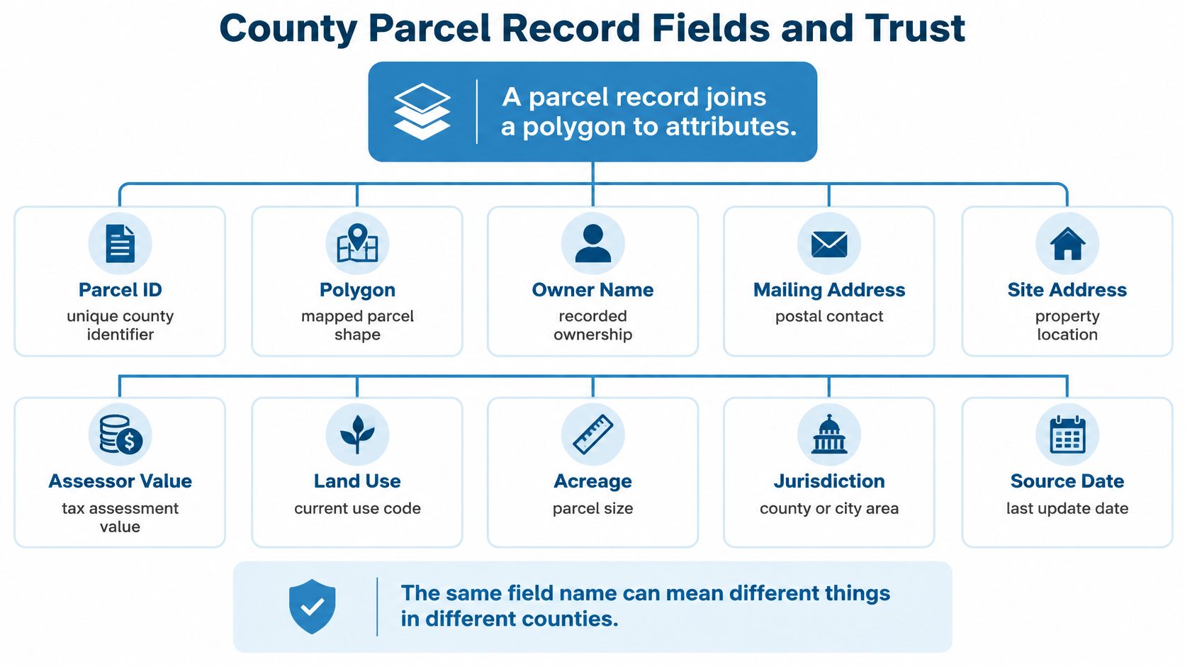
The record has two connected halves. A polygon represents the mapped outline, while attributes hold information such as the owner of record, situs address, and assessed value. A parcel number connects the map feature to the administrative record.
Think of the map as the label on a filing folder and the attributes as the papers inside. The folder can contain complete papers while its label is slightly off. Likewise, a well-populated assessment record doesn't establish that the mapped boundary is precise.
Local administration
Local records remain operationally important even where a national surveying framework supplies reference geometry. The Public Land Survey System was created in 1785, but a 2007 study cited in Regrid's history of parcel data found that only about one-third of U.S. counties published digital parcel data.
Digitization alone doesn't resolve the integration problem. Counties can publish different identifiers, coordinate systems, field definitions, and release schedules. An aggregator must reconcile those differences without removing the information needed to trace a record back to its source.
Practical rule: A national parcel layer is an integration product, not a replacement for county stewardship.
For production work, distinguish these responsibilities:
- Local maintenance: Agencies record transfers, administer assessments, and revise tax maps.
- State coordination: Programs collect participating jurisdictions and establish shared specifications.
- National integration: Data teams normalize records for cross-market searches and analysis.
Lenders need both the property record and a reliable spatial match. Insurers need boundaries connected to attributes they can interpret. Portal builders need consistent search results, while logistics teams need property locations that connect to usable access points.
None of those tasks is solved by assembling polygons alone. A national system needs common definitions, retained provenance, and explicit quality controls alongside geographic coverage.
Which fields does a county parcel record contain and how far can each be trusted?
A parcel record joins a polygon to attributes, but matching field names don't guarantee matching definitions across counties. Use the following checks before treating a county field as a standardized business input.
Core parcel fields, what they hold and how to verify them
| Field | What it holds | Typical source | Verify before use |
|---|---|---|---|
| Parcel ID (APN) | County-assigned number identifying the parcel | County assessor | Check the county's format; don't assume a shared pattern |
| Situs address | Physical address tied to the parcel | Assessor or addressing office | Distinguish it from the mailing address |
| Geometry | Polygon outline of the parcel | County GIS or tax map | Treat it as a map estimate, not a survey-grade legal boundary |
| Owner of record | Name and mailing address on the tax roll or deed | Assessor and recorder | Establish the roll or recording date |
| Assessed value | Value used for property-tax assessment | County assessor | Don't substitute it for market price |
| Land use code | Classification of parcel use | County assessor | Obtain the county's code dictionary |
| Acreage | Recorded or calculated parcel area | Assessment system or geometry calculation | Compare mapped and recorded acreage |
| Building characteristics | Beds, baths, year built, building area | Assessor property record | Investigate blanks, especially on vacant or rural parcels |
| Zoning | Zoning designation | Planning office or GIS layer | Check whether it requires a separate spatial join |
| Last sale | Date and price of the last recorded transfer | County recorder | Check transfer type and whether consideration is recorded |
The Connecticut parcel-data creation guidance describes connected geographic features linked to records and promotes consistent attributes and metadata. That structure matters because a field can be populated correctly under a local definition yet still be unsuitable for a cross-county comparison.
Address and value traps
The situs address identifies the property's physical location. The mailing address identifies where the owner receives correspondence. Sending a service vehicle to an owner's mailing address is a field-selection error, not necessarily a geocoding error.
Assessed value is a tax-administration figure, not an asking price, sale price, or automated valuation. Preserve its assessment year and local definition so downstream users don't compare unlike values.
Building characteristics and zoning introduce another join problem. An assessor's building record may describe improvements, while the planning office maintains zoning separately. A blank zoning field in the assessor export doesn't prove that the property has no zoning designation.
Identifiers and traceability
Store APNs as text so leading zeros and meaningful punctuation survive ingestion. The APN real estate guide provides additional context for using assessor parcel numbers as property identifiers.
Keep the original parcel ID and county name together in every row, ideally with a jurisdiction code and stable internal key. Never discard the source identifier after creating your own.
Before merging counties, approve a field dictionary that records meaning, units, null handling, source office, and transformation rules. Trust should attach to a defined field from a known source, not to a familiar column name.
Why does a statewide parcel map miss counties and how do I find the gaps?
A statewide layer can look complete while covering only the counties whose records the state may redistribute. Permission shapes coverage as much as geography does. Check the contributor list before treating the map's extent as evidence of availability.
The New York statewide tax-parcel layer shows how this plays out: it includes data from 38 counties, directs users to obtain other counties' records locally, and warns that geometry accuracy differs among contributors. A statewide basemap can sit underneath a partial parcel dataset.
Missing jurisdictions are only the first gap. Contributing counties supply records with different geometry precision, attribute completeness, and publication dates, and a shared display style hides those differences. Statewide projects also tend to receive county submissions in differing formats, so reviewers end up checking attributes, completeness, geometry, and processing errors county by county. A common container doesn't eliminate local differences.
County-level coverage audit
Build a coverage manifest before running statewide totals. Each check below answers a practical question: can this layer support the decision in front of you?
- Compare contributors with the full county list. Mark absent jurisdictions explicitly rather than leaving their status blank.
- Reconcile parcel counts. Compare the loaded county count with the assessor's total and investigate different counting rules before treating a difference as missing data.
- Record the load date. Keep it separate from the source release date so an old publication doesn't look fresh because you downloaded it recently.
- Read accuracy documentation. Record limitations in a field analysts can filter, not only in an attached PDF.
- Confirm redistribution terms. Document whether internal analysis, customer display, and onward distribution are permitted.
Coverage warning: Missing data isn't evidence that a property type, exposure, or investment opportunity doesn't exist.
Treat coverage as a jurisdiction-level inventory, with parcel-level exceptions underneath it. The same discipline applies when combining parcels with other GIS data layers: overlapping map extents don't prove matching coverage.
Label each county included, missing, or stale before analysis, then add attribute-availability and permission flags. The tolerance for gaps depends on the decision. A screening model can work around a flagged stale county; a statewide exposure total can't. A partial dataset supports useful work only when the analyst knows which population the result describes.
Which parcel geometry fits my decision and which needs a survey?
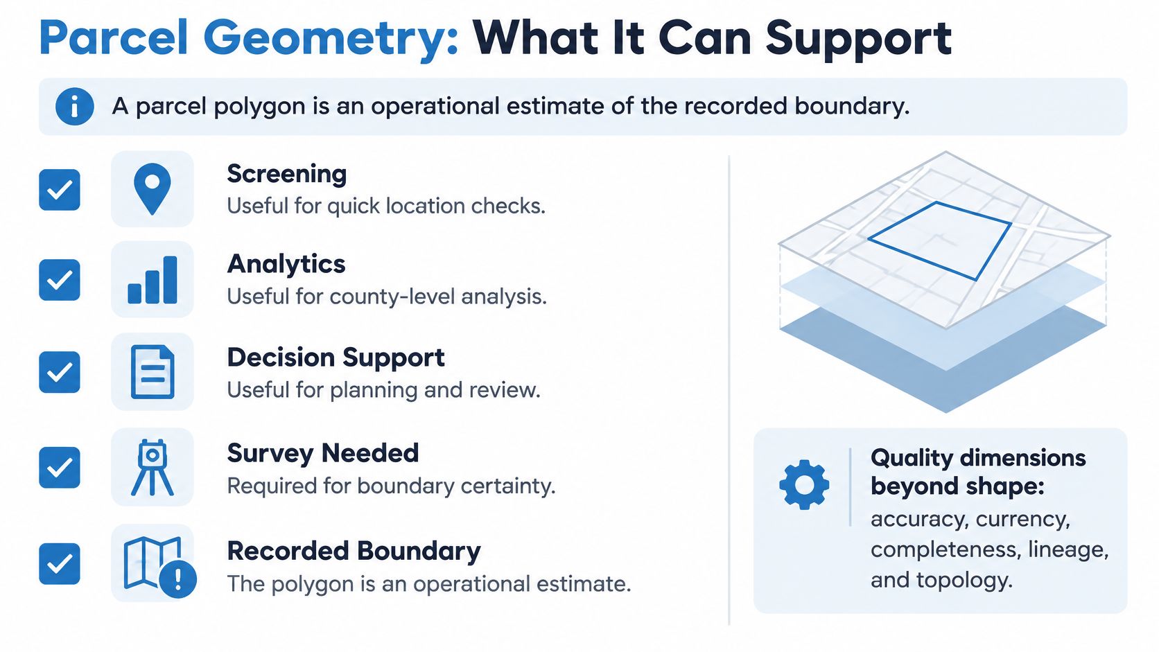
A clean parcel polygon is an operational estimate of a recorded boundary, not automatic evidence of a legal boundary. It can support screening and analytics, but boundary-sensitive decisions require stronger confirmation.
Washington County, Minnesota, reports in its parcel-data guidance an 8-foot horizontal accuracy test at the 95% confidence level for digitized features. The same guidance cautions that parcel boundaries aren't based on individual field surveys and may differ from monumentation and recorded legal descriptions. A published accuracy result doesn't override the county's stated limitations, so read both numbers and caveats before citing a layer's precision.
Quality beyond appearance
A polygon can align with imagery while carrying an outdated owner or sitting beside a missing parcel. Evaluate quality across distinct dimensions:
- Positional accuracy: Agreement with accepted reference locations.
- Attribute accuracy: Correct ownership, use codes, and other record values.
- Completeness: Presence of the parcels and fields needed for the analysis.
- Timeliness: Currency of the particular boundary or attribute.
- Lineage and topology: Traceability to source material and valid relationships between neighboring features.
The Connecticut cadastral standards and guidelines distinguish these quality concerns rather than reducing quality to visual alignment. For a county mosaic, inspect overlaps, gaps, invalid geometries, and seams separately from attribute checks.
Decision-specific evidence
The evidence must fit the consequence of being wrong. Wasatch County, Utah, remapped its legacy deed-based parcels after an accuracy assessment fell below its target, as described in Esri's parcel modernization account. A county willing to rebuild its geometry layer is a reminder that even maintained parcel maps can carry systematic error until someone measures it.
Geometry required by decision type
| Decision | Geometry it can accept | Confirm with | Risk if skipped |
|---|---|---|---|
| Regional screening and portfolio analytics | Parcel polygons | County GIS notes and assessor parcel count | Missed or duplicated portfolio parcels |
| Delivery routing and service zones | Polygon plus geocoded address point | Address point and county road network | Wrong access point or street side |
| Automated property matching and ML training | Polygon with separate confidence scores | Parcel ID and recorded deed | False adjacency between neighboring lots |
| Lending, valuation and lot-size calculations | Recorded plat or licensed survey for boundary-sensitive conclusions | Plat, survey, and assessment acreage | Overstated or understated acreage and value |
| Boundary disputes and legal decisions | Survey-grade boundary evidence | Recorded survey and title report | Legal exposure from a map estimate |
For land transactions, parcel screening and transaction guidance serve different purposes. Cyber Homes' guide to selling vacant land for cash addresses the sale process; it shouldn't replace verification of the land being conveyed.
If a boundary assumption changes a dollar value, a legal right, or a person's access, require a recorded plat or licensed survey appropriate to the decision.
Keep geometry confidence separate from attribute confidence. Otherwise, a reliable ownership match can accidentally make an uncertain boundary appear equally reliable.
How often does each county refresh its parcel layers?
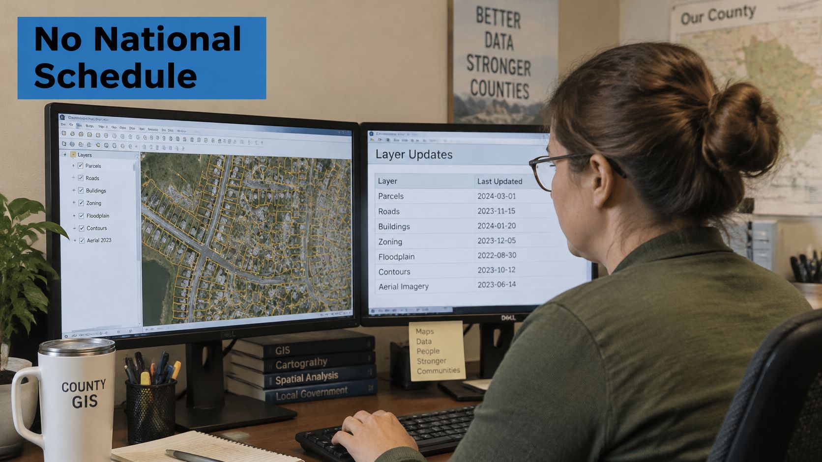
A parcel file can be fresh enough for routing and still too old for a valuation cutoff. There is no national refresh schedule: counties set cadences locally, and many publish attributes, maps, and sales displays on different clocks. Judge each layer by the decision it feeds, not by whether the download ran this week.
The Los Angeles County assessor FAQ describes weekly updates to its parcel layer, maps, characteristics, assessments, and recent-sales display, paused between the annual roll release in July and the auditor's tax extension in late September. That is one county's policy, useful because it shows an attribute feed and a map layer can share a schedule yet still stop for a fixed assessment-window freeze.
Refresh cadence to verify for each layer
| Layer | Los Angeles County example | What to confirm locally |
|---|---|---|
| Parcel attributes | Weekly characteristics and assessment updates, paused July to late September | Which office publishes the field and its release identifier |
| Parcel boundaries | Parcel layer and maps update on the same weekly cycle, with the same pause | Whether geometry follows the attribute feed or a separate map release |
| Sales and assessment display | Weekly recent-sales and assessment display, with the same pause | Whether display lag differs from the underlying record change date |
Layer-specific freshness controls
Track source publication date, retrieval date, and load date separately. Retrieval proves when your team fetched a file, not when the county changed its contents.
Use a release-aware routine:
- Find the publication policy for each county and layer.
- Date each loaded layer, retaining the county's release identifier when available.
- Flag superseded records when a newer release exists but hasn't been ingested.
- Schedule around known freezes, rather than assuming a fixed monthly pull always captures new material.
A slower layer is not automatically stale. Define freshness against the expected publication policy, then let the workflow decide whether that cadence supports the decision at hand.
Which access route delivers consistent parcel data across many counties?
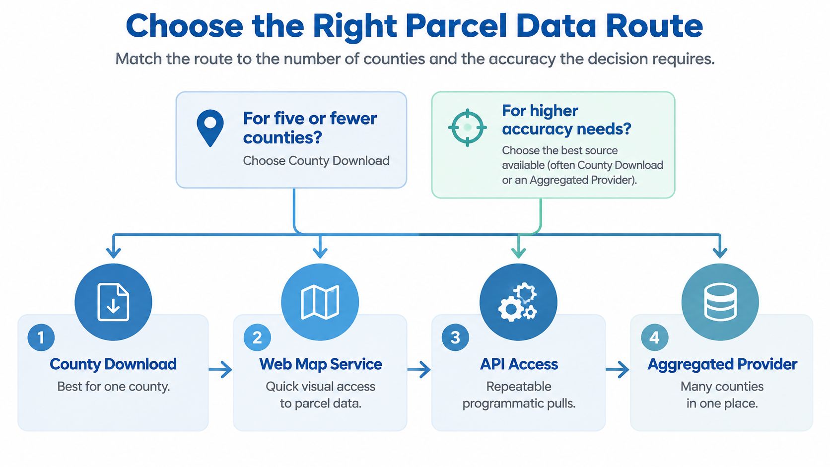
Match the access route to geographic scope, repeatability, and the evidence your decision requires. County portals work for small, occasional projects; aggregated feeds become more practical when maintaining cross-county consistency is an ongoing responsibility.
Access routes for multi-county parcel data
| Route | Best for | Coverage | Refresh | Main risk |
|---|---|---|---|---|
| County portals and direct requests | Five or fewer counties, one-off pulls | Requested counties only | County-set, checked per layer | Manual schema mapping for every county |
| State aggregated parcel layer | Statewide screening where redistribution is allowed | Contributing counties only | Each contributor's publication schedule | Missing counties and mixed precision |
| Commercial parcel API or bulk feed | Consistent fields across many counties with ongoing refresh | National offerings delivered through a common schema | Provider-managed; evaluate field-level freshness | Normalized fields still need provenance checks |
| In-house pipeline | GIS teams maintaining a custom long-term schema | Sources the team ingests | Team-managed ingestion schedule | Ongoing maintenance of every feed |
The small-project cutoff is a practical recommendation, not a technical limit. I would start with direct county access for five or fewer counties when the question is one-off and manual validation is manageable.
Delivery and operating cost
The actual cost of direct access includes staff time for field mapping, failed downloads, permission reviews, release monitoring, and exception handling. An open download can be inexpensive to acquire and expensive to operate.
A web map service is useful for visual inspection, but confirm query limits, export permissions, and attribute availability before treating it as an ingestion endpoint. Viewing a county's map doesn't establish permission to copy or redistribute its underlying records.
For repeatable national work, choose between request-based access and delivered datasets according to the workload. Use an API for application lookups and targeted retrieval; consider bulk delivery for warehouse joins, model training, and portfolio-wide reconciliation. The API versus bulk real estate delivery guide explains that operational choice.
Our API covers 169 million+ parcels with 1,000+ data points per property, delivered through one API. We return the owner of record, vesting, APN, and legal description from county assessor and recorder data; these are research records, not certified copies. Our Legal & Title solution verifies ownership, legal descriptions, and property boundaries, but verification doesn't turn a research feed into a certified county instrument.
Normalization workflow
Build the ingestion process so a reviewer can explain every transformation and isolate every rejected record. The FGDC cadastral framework standard separates discovery and exchange information from the parcel dataset, supporting explicit metadata rather than an undifferentiated national layer.
Inventory target counties and publication policies. Record the responsible office, access method, permitted uses, release pattern, and metadata location. Assign an owner to each source so a broken endpoint becomes a tracked maintenance task.
Map local fields into a canonical schema. Include parcel ID, geometry, owner, situs address, and assessed value, while retaining raw source values beside normalized values. Document code translations and reject ambiguous mappings rather than guessing.
Preserve geographic and temporal context. Keep county name, source date, coordinate reference system, and internal key on each record. Use an appropriate projected coordinate system for area calculations rather than calculating acreage directly from longitude and latitude.
Test identifiers and county seams. Run duplicate-ID checks within each jurisdiction, validate geometries, and inspect overlaps and gaps along county borders. Don't automatically delete duplicates until you determine whether they represent multipart parcels, administrative interests, or an ingestion mistake.
Reconcile counts and log exceptions. Compare the imported population with assessor totals, recording the counting basis and excluded record classes. Store unmatched records in an exception table so later releases can resolve them without concealing the original discrepancy.
Refresh by layer and preserve history. Schedule ingestion around source releases, validate changed records, and keep previous accepted versions. When a split or merge changes parcel identity, retain predecessor and successor relationships rather than overwriting history.
QGIS is suitable for reviewing spatial exceptions; PostGIS supports repeatable geometry checks, spatial joins, and county-level reconciliation. Keep test results in queryable tables so analysts can exclude unsuitable records without interpreting a processing log.
Acceptance before deployment
An acceptance test should measure whether the feed supports the intended workflow, not only whether the delivery succeeded. Define the required fields, acceptable missingness, source-date requirements, and escalation path before testing.
- Coverage acceptance: Reconcile jurisdictions and parcel populations.
- Semantic acceptance: Confirm that normalized fields preserve local meaning.
- Spatial acceptance: Review boundary-sensitive matches and seam exceptions.
- Operational acceptance: Test replacement loads, failed jobs, and rollback.
- Evidence acceptance: Separate research outputs from certified-record requirements.
For ownership confirmation beyond screening, retrieve the relevant recorded instruments from the county recorder. Boundary questions may also require a recorded plat or licensed survey; a current owner field doesn't answer them.
Start with a test pull of 20 counties selected to challenge the pipeline, including different publication formats and access conditions. Reconcile those counties against assessor totals, review exceptions, and approve the acceptance results before building application logic or models on top.
We provide county-derived property information through a unified API, including parcel identifiers, ownership details, and legal descriptions for cross-county research. Visit BatchData to evaluate a sample against your target counties, required fields, and layer-specific freshness requirements before committing to production.