

































Change detection is the process of identifying differences over time, either by comparing visual data like satellite images or by detecting the exact point when a time series materially shifts. In real estate, that means spotting both a new structure on a parcel and a meaningful change in records such as ownership, valuation, permits, liens, or mortgage status.
Initial associations with change detection often include maps, imagery, and before-and-after satellite views. That definition is real, but it's incomplete for anyone building products in proptech, lending, servicing, insurance, or investment operations. The higher-value use case is often statistical: catching the moment a property's data profile changes enough to affect underwriting, outreach, asset management, or risk.
Here's the practical split:
| Type | What it detects | Typical real estate outcome |
|---|---|---|
| Geospatial change detection | Physical changes visible in imagery | New construction, demolition, land clearing, pool removal |
| Statistical change detection | Significant shifts in time-series or record attributes | Ownership transfer, AVM movement, lien activity, permit pattern change |
| Operational change monitoring | Event-driven updates from property data systems | Portfolio alerts, servicing triggers, acquisition signals |
If you're an investor or developer, the question isn't just what changed. It's which changes matter enough to act on.
Introduction
The common definition of change detection misses where a lot of real estate value sits. Most existing content defines change detection strictly as a remote sensing or image processing task, creating a critical gap for real estate professionals who need to understand “change detection” in the context of statistical time-series data such as shifts in valuation or mortgage status distributions, as noted in this change detection overview for social sciences.
That gap matters because modern property operations don't run on imagery alone. They run on state changes across records, events, and model outputs. A developer wants to know when permit activity suggests a site is moving. A lender wants to know when risk indicators change. A buyer wants to know when ownership, distress, or listing behavior creates an opening.
Why the standard definition falls short
Remote sensing gives you a view of the parcel. Statistical monitoring gives you a view of the asset's behavior.
Those are not the same thing.
A vacant lot turning into a building is one kind of change. A property's valuation pattern shifting, a lien appearing, or an ownership transfer posting is another. In production systems, teams usually need both.
Practical rule: If the business decision depends on timing, not just visibility, you're usually dealing with statistical change detection.
What matters in practice
- Physical changes: Useful for construction tracking, site verification, and land use monitoring.
- Record changes: Useful for acquisition, underwriting, compliance, servicing, and portfolio surveillance.
- Confidence filtering: Useful for separating real signals from noise before an analyst wastes time.
The primary job of change detection isn't to say that two observations are different. It's to decide whether the difference is meaningful, timely, and actionable.
What Is Change Detection Beyond Satellite Images?
For real estate teams, the higher-value change often happens in records before it shows up in imagery. A satellite image can confirm that a site changed. It cannot tell an acquisitions team, lender, or developer fast enough that ownership transferred, permits started clustering, or a valuation pattern broke from its prior range.
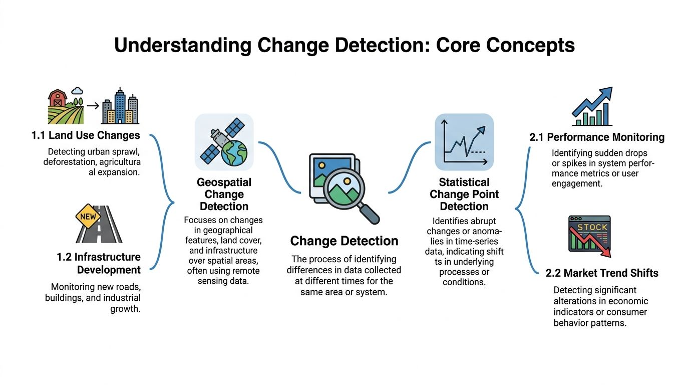
Change detection has two valid meanings. In geospatial work, it identifies differences in the state of an object or area by comparing observations from different times. In statistical analysis, it identifies the point where the behavior of a process or time series materially shifts.
The geospatial definition
In GIS and remote sensing, change detection means identifying and measuring spatial differences in natural or built features by comparing images from different dates.
That version is familiar because it is visual. You compare the same parcel across time and isolate what physically changed.
For real estate, geospatial change detection answers questions like these:
- Did a new structure appear
- Did land get cleared
- Did a roof, pool, or solar installation change
- Did visible development activity spread across a corridor
That matters for site verification, construction tracking, land use review, and corridor monitoring. If you want a broader property-market view, this guide on geospatial mapping and property trends adds useful context.
The statistical definition
In statistical analysis, change detection, often called change point detection, is the process of identifying when the underlying behavior of a stochastic process or time series changes, as described in Wikipedia's overview of change detection.
In product terms, the idea is straightforward. A property attribute or event stream has a normal pattern. Then the pattern shifts enough that the old baseline no longer fits.
For real estate data, that usually means changes such as:
- an ownership record updates from one entity to another
- assessed or modeled value stops drifting and starts moving in a different regime
- permit activity changes from occasional filings to sustained momentum
- lien or mortgage events alter the asset's risk profile
- listing behavior starts to signal distress, repositioning, or an upcoming sale
These are not academic edge cases. They drive acquisition timing, underwriting review, borrower outreach, and development pipeline tracking.
What the distinction means for a property business
Geospatial change detection answers what changed on the parcel. Statistical change detection answers when the asset's behavior changed in the data.
For an investor, that timing difference affects entry price and deal competition. For a developer, it affects whether a site is still early, already moving, or too late to pursue. For a lender or servicer, it affects how quickly a team can react to emerging risk.
A simple example makes the trade-off clear. Imagery may confirm new site work after it is visible from above. Permit filings, contractor activity, ownership changes, or value-pattern shifts can signal the same story earlier, although with more noise and more need for filtering. Good systems use both, because visual confirmation is persuasive and record-level monitoring is faster.
Why this definition matters in product design
If a team is building search, alerts, underwriting tools, or portfolio monitoring, the definition of change detection shapes the system itself.
Parcel verification products need geospatial workflows. Operational alerting products need statistical monitoring across ownership, valuation, permits, liens, listings, and other changing attributes. Real estate platforms that serve acquisitions or asset management usually need both, because users care about physical reality and decision timing at the same time.
The common mistake is treating change detection as an image problem only. In practice, many proptech products create more value by detecting shifts in ownership, valuation, permit, and risk data before an analyst has any reason to open a map.
How Do Different Change Detection Methods Compare?
Different methods solve different change problems. The right choice depends on the data type, the action latency you need, and how much noise the business can tolerate.
The basic methods
The simplest approach is a diff. You take two states and compare them.
That works well for fields like owner name, tax status, permit presence, parcel characteristics, or object counts in imagery. It's cheap to compute and easy to explain. It also breaks down when the underlying data fluctuates naturally and not every difference deserves an alert.
The next level is event detection. Instead of comparing full snapshots, you watch for named events such as deed recording, pre-foreclosure status, lien filing, or permit issuance. This is often better for operations because it maps directly to business workflows.
Then there's time-series change point detection. This method looks across a sequence and tries to identify when the distribution or behavior shifted. It's the right choice when your issue isn't one changed field but a change in pattern.
Change Detection Method Comparison
| Method | Core Principle | Best For | Primary Trade-off |
|---|---|---|---|
| Snapshot diffing | Compare current state to prior state | Ownership fields, attribute updates, simple before-and-after checks | Fast and simple, but noisy when fields fluctuate |
| Event-based detection | Trigger on explicit record events | Liens, permits, transfers, foreclosure workflows | Clear business meaning, but depends on event quality |
| Time-series change point detection | Detect a shift in data behavior over time | AVMs, equity movement, listing activity, risk monitoring | Stronger signal detection, but more complex to tune |
| Image differencing | Compare raster or pixel changes between dates | New structures, site disturbance, land cover change | Useful for physical changes, vulnerable to environmental noise |
| Object-based change detection | Compare extracted objects or counted features | Solar panels, pools, buildings, lot improvements | More interpretable, but requires reliable object extraction |
What GIS workflows get right
In GIS and remote sensing, a change detection workflow typically uses four phases: image selection and preprocessing, data transformation, classification of the differenced image, and accuracy assessment, as described in Esri's GIS dictionary entry on change detection.
That framework is worth borrowing even outside imagery because it enforces discipline:
- Prepare the input carefully: Clean timestamps, normalize source fields, and align parcel identities.
- Transform before comparing: Raw fields often need standardization before differences mean anything.
- Classify the result: Not every difference is worth action.
- Check accuracy: A bad alerting system teaches users to ignore alerts.
Batch versus streaming
This is one of the biggest product decisions.
Batch processing works when the use case is periodic review. You ingest large property updates, compare them to the prior state, then generate a change report. It's operationally simpler and often enough for reporting, market analysis, and low-frequency monitoring.
Streaming or near-real-time processing works when timing changes the business value. If a servicing team wants to react when a distress event appears, or an investor wants alerts as record changes arrive, batch latency becomes a business problem.
Here's the practical trade-off:
- Batch is easier to manage and usually cheaper to reason about.
- Streaming reduces reaction time but raises complexity around state management, duplicate events, and threshold tuning.
What works and what doesn't
What works:
- methods that align with the business action
- thresholds tied to impact, not just any difference
- review loops that expose false positives quickly
What doesn't:
- treating every changed field as meaningful
- mixing noisy sources without normalization
- shipping alerts before validating whether the change is operationally useful
A product manager should ask one question before picking a method: What decision changes when this signal fires? If there's no clear downstream action, the detection method is probably too loose.
Why Is Change Detection a Competitive Edge in Real Estate?
Change detection creates an edge when it turns raw updates into earlier decisions. In real estate, speed matters, but signal quality matters more.
The changes that actually move money
A property investor doesn't need an abstract “update feed.” They need to know when a parcel becomes worth a call, a bid, a re-underwrite, or a risk review.
Here are the high-value categories:
- Ownership changes: A transfer can reset outreach strategy, acquisition assumptions, or servicing workflow.
- Lien and distress activity: These changes can alter risk posture fast.
- Permit activity: New permits can signal improvement plans, redevelopment, or changing use.
- Valuation behavior: A material shift in AVM or equity behavior can trigger repricing or portfolio review.
That's why statistical change detection matters so much in property data. It catches changes in state, not just changes in appearance.

Robust changes beat noisy changes
In real estate imagery workflows, effective change detection focuses on significant changes with high confidence, such as a property moving from zero solar panels to one or a new building appearing on a vacant lot, and analysts can sort by change magnitude to filter out minor events, as explained in Nearmap's example of change detection.
That principle applies equally well to record data.
A significant change in property records might be:
- a recorded ownership transfer
- a newly attached lien
- a permit status moving into a more consequential phase
- a sustained shift in valuation behavior rather than a one-off adjustment
A weak change is the opposite. It looks different, but nobody should act on it yet.
The fastest way to kill trust in an alerting product is to notify on every tiny update that doesn't change a decision.
Real estate use cases that benefit immediately
Acquisition and lead generation
Ownership changes can create fresh outreach windows. Permit activity can reveal capital being deployed into a neighborhood before pricing catches up. Distress-related changes can move a property into a different acquisition lane.
Lending and servicing
A lender or servicer cares about more than collateral imagery. They care whether the property's data profile now implies increased risk, a servicing event, or a need for human review. Change detection gives operations teams a way to monitor that continuously instead of relying on manual audits.
Development and market intelligence
Developers care about signals that precede visible completion. Permit patterns, adjacent site activity, and parcel-level physical changes can all inform where competition is building and where land use is shifting. This is also where geospatial inputs can improve pricing context, as shown in this piece on geospatial analysis and automated valuation models.
The investor's version of the question
For an investor or developer, the useful framing is blunt:
| Signal | Why it matters | Likely action |
|---|---|---|
| Ownership transfer | New control of the asset may change motivation and timing | Refresh outreach or underwriting |
| Permit activity | Suggests capital improvement or repositioning | Reassess nearby opportunities |
| Lien or distress update | Risk and negotiation posture may change | Escalate review |
| Physical site change | Confirms development, demolition, or added improvements | Update comps or development assumptions |
Change detection becomes a competitive edge when teams stop treating it as a map feature and start using it as a decision trigger.
How Do You Implement a Change Detection System?
Implementation succeeds or fails on workflow design. If a detected change does not lead to a clear action, teams get noise instead of an operating advantage.
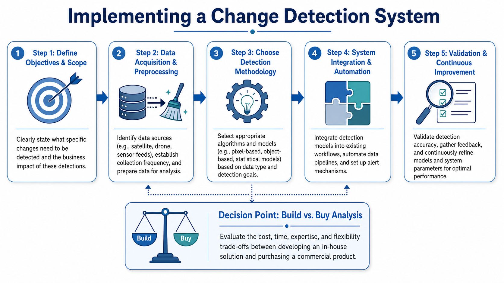
Start with the decision, then work backward into data and models. In real estate, that means asking a concrete question such as: what should happen when beneficial ownership changes, when permit activity suggests a renovation, or when an assessed value move is large enough to affect outreach, underwriting, or asset review?
Define the monitored event
Set three things before you choose tooling:
What entity are you tracking?
A parcel, property, borrower, loan, portfolio, or submarket.What change matters?
Ownership transfer, permit issuance, valuation shift, lien filing, listing status change, or a physical attribute update.What operational response follows?
Create a CRM task, route an alert to an analyst, refresh a score, reopen underwriting, or push an event into an internal system.
That discipline matters because real estate data changes for many reasons, and not all of them deserve attention. A mailing address correction should not compete with a deed transfer. A one-period valuation wobble should not carry the same weight as a sustained shift paired with a permit and contractor filing.
Choose your system design
The trade-off is speed versus control.
Build in-house if your team needs custom logic tied to proprietary investment rules or servicing workflows. That path usually requires source ingestion, entity resolution, historical state storage, field-level diffing, threshold logic, and delivery infrastructure. It also means owning the ugly parts: county timing inconsistencies, identifier drift, source conflicts, and alert QA.
Buy or integrate if your product team cares more about getting monitored property changes into the application than assembling the raw data pipeline. That is often the right call for firms that want analysts and acquisition teams acting on changes within days, not waiting through a long data engineering project.
BatchData is one example of this route. The product supports property records, API access, and monitoring workflows that fit event-driven applications. The point is not the vendor name. The point is shortening the distance between a source update and a business action.
Build the baseline correctly
Every change detection system needs a prior state that you trust.
For property monitoring, that baseline usually includes ownership fields, assessed and estimated value fields, debt and lien indicators, permit status, listing history, and prior alerts. The baseline should be time-stamped and versioned. Without that, teams cannot tell whether a record changed, whether the change persisted, or whether the same event already triggered work last week.
This is also where identity resolution becomes a real engineering problem. The same asset may appear under different parcel formats, address conventions, owner spellings, or source-specific IDs. A graph-based entity layer helps reconcile those records into one monitored object. That is the practical value behind a geospatial knowledge graph for real estate.
Set thresholds that reflect business risk
Thresholds are rarely just numeric cutoffs.
A useful rule usually combines four tests:
- Magnitude: How large is the change?
- Field importance: Is this attribute material to the use case?
- Persistence: Does it survive across multiple refreshes?
- Context: Does it matter for this property type, geography, or investment strategy?
For example, a small valuation change on a stabilized apartment asset may not matter. The same movement on a land parcel in pre-development, combined with a new permit and ownership update, may justify immediate review because it changes the probability of a nearby competitive project.
Teams that build alerting for high-consequence systems often learn the same lesson. Monitoring logic has to be tied to action and failure cost, not just signal detection. This technical guide for reliability engineers is useful on that point because it treats detection as an operational system, not a model in isolation.
Implementation rule: trigger alerts when a change could alter a human decision, pricing assumption, or workflow priority.
Deliver alerts where work already happens
A well-designed model still fails if the output lands in a dashboard nobody checks.
Send changes into the systems teams already use:
- CRM queues for acquisition and brokerage outreach
- underwriting tools for loan or deal review
- servicing platforms for risk monitoring
- portfolio dashboards for asset management
- webhooks or event buses for internal automation
In practice, real estate teams begin to find value. An ownership change can re-rank an outbound list. A permit event can prompt a developer to revisit nearby site assumptions. A lien update can move an asset into a higher-review queue before the quarterly manual audit would have caught it.
Expect these failure points early
The first problems are usually predictable:
| Failure point | What goes wrong | Fix |
|---|---|---|
| Entity matching | The same property appears as multiple records, so alerts fragment or duplicate | Normalize parcel, address, and owner entities early |
| Source volatility | Temporary updates fire alerts that disappear on the next refresh | Add confidence scoring and persistence checks |
| Weak threshold design | Teams get flooded with low-value changes or miss meaningful ones | Tune by workflow, property type, and user feedback |
| No response owner | Alerts are delivered, but no team is accountable for acting on them | Assign downstream actions and SLAs |
| No historical audit trail | Teams cannot explain why an alert fired or compare logic changes over time | Store versions of baselines, rules, and outputs |
The technical challenge is not spotting a difference between two records. The hard part is deciding which differences deserve attention, and doing it consistently enough that investors, developers, and operators will act on the result.
Best Practices for Production-Grade Monitoring
A change detection product fails in production long before it fails technically. It fails when acquisitions stops trusting ownership alerts, when asset management ignores valuation shifts, or when development teams learn that permit signals arrive too late to affect a bid or underwriting model.
For property data, production monitoring means measuring whether the system is catching meaningful record changes with enough consistency that teams will act. A model can detect a field-level difference perfectly and still create no business value if the alert arrives after a title review is complete, or if a temporary assessor update keeps firing noise into the queue.
That is the operating standard.
The operating checklist
- Measure alert quality by workflow: Track false positives and missed changes by use case. An acquisitions alert, a servicing alert, and a permit-monitoring alert should not share the same success criteria.
- Retune thresholds on a schedule: County practices change, assessors revise values in batches, and permit feeds vary by jurisdiction. Thresholds that worked for multifamily in one market may be wrong for industrial or land in another.
- Monitor source freshness and revision patterns: Late feeds, partial refreshes, and retroactive corrections can make a stable property look volatile. Watch for lag and for sources that frequently rewrite recent history.
- Score alerts by confidence and impact: Separate likely ownership transfers from weaker ownership hints. Separate minor valuation adjustments from changes large enough to affect outreach, risk review, or hold strategy.
- Version rules, baselines, and matching logic: Teams need to know whether alert volume changed because the market changed or because your entity resolution and detection rules changed.
- Audit actionability, not just throughput: Review which alert classes lead to calls, reviews, site revisits, or model changes. If nobody acts on a category, remove it, downgrade it, or redesign it.
The trade-off is straightforward. Tight thresholds reduce noise but miss early signals. Loose thresholds surface more possible change, but they also push analysts into review work that does not change a decision. The right setting depends on the cost of being wrong. Missing a deed transfer near a target assemblage can cost a developer a real opportunity. Flooding an acquisitions team with weak owner-name variations wastes time and lowers trust.
A practical monitoring setup usually includes weekly exception review, monthly threshold tuning, and a clear owner for each alert class. It also includes replay testing. Before shipping a rule change, run it against historical property records and compare what would have fired. That catches obvious regressions before users see them.
The firms that get value from change detection treat monitoring as part of the product, not a cleanup task. In real estate, that discipline shows up in better timing. Investors see ownership movement soon enough to adjust outreach. Developers catch permit activity early enough to revisit nearby parcels. Operators spot valuation, lien, or distress changes while there is still time to act.
If your team needs property change monitoring tied to real operational workflows, BatchData provides access to large-scale U.S. property records, daily updates, and API-based delivery that can support alerting across ownership, valuation, permit, lien, listing, and distress-related changes.