





































A lender can be halfway through closing, confident the file is clean, and then learn the property sits in a Special Flood Hazard Area. That one finding changes the file fast, because flood zone determination is a compliance decision, an underwriting input, and a disclosure trigger, not just a map lookup. FEMA frames the high-risk zone as a 1% annual chance area, which is why the old “100-year flood” phrase still shows up, and why the risk is still meaningful over a standard mortgage term. FEMA's flood zone glossary is the place to start when you need the regulatory frame, not a simplified summary.
What matters in practice
- High-risk zones like A and V can trigger mandatory flood insurance for federally backed mortgages.
- Zone X is lower risk or moderate risk, but it is not the same thing as no flood exposure.
- Insurance, underwriting, and disclosure all depend on the zone result.
- Scale and boundary quality matter when a property sits near a line, especially in coastal or revised-map areas.
For teams that need continuing education on the insurance side, the PIA Southern Alliance flood insurance training page is a useful companion resource because it keeps the map conversation tied to policy handling, not just property search. If you're building a broader risk workflow, BatchData's hazard and real estate coverage gives you a sense of how flood status fits into a larger property data stack.
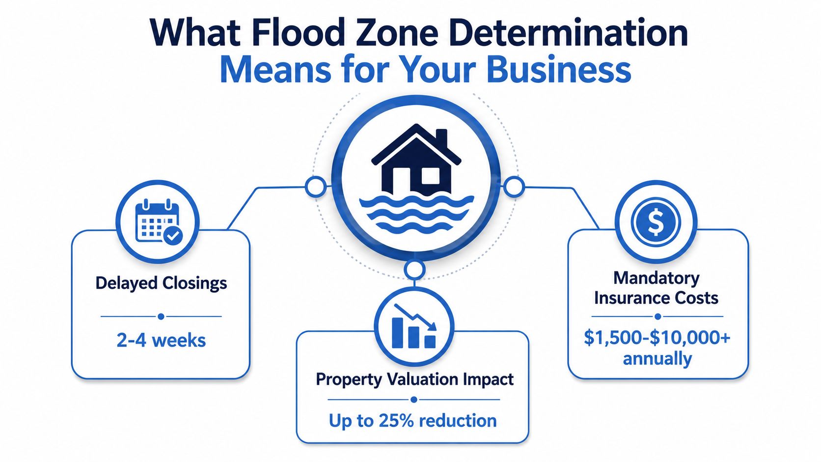
What Flood Zone Determination Means for Your Business
A flood zone determination tells you which FEMA flood zone applies to a specific property, and that result can change the whole transaction path. FEMA's framework treats SFHAs as places with a 1% annual chance of inundation, and FEMA also notes that translates to about a 26% chance over a 30-year mortgage term. That is why this is not a label for the file notes. It shapes loan conditions, insurance obligations, and how risk gets disclosed and priced. FEMA's flood zones glossary is explicit on the zone framework, including the meaning of A, V, and Zone X.
Why the label changes decisions
A bad zone read shows up fast in operations. In lending, it can stop a closing until coverage is in place. In insurance, it changes how the file is underwritten and how the exposure is discussed with the applicant. In portfolio work, it becomes a screening variable that helps teams sort risk by geography instead of by guesswork.
The important split is simple:
- A and V zones mean high-risk SFHAs.
- Shaded Zone X generally indicates 0.2% to 1% annual chance flood risk.
- Unshaded Zone X indicates less than 0.2% annual chance flood risk.
Practical rule: treat the zone as a regulatory starting point, not the final answer. If the file has elevation questions, boundary ambiguity, or a recent map change, the zone label alone is not enough.
Who needs the result and why
Lenders need a determination that stands up in audit. Insurers need a risk read that aligns with policy rules. Investors need a consistent portfolio lens, especially when they're screening many properties at once. Proptech teams need dependable flood inputs so their product does not tell users the wrong thing at the worst possible moment.
FEMA's glossary makes the point that flood zone designation is not just descriptive, it directly affects insurance requirements, underwriting, and disclosure decisions. That is why map literacy matters as much as property literacy. In a closing file, a sloppy zone read can create delays, exceptions, and rework that no one wants to explain late in the process. For teams building repeatable workflows, the operational side of flood zone checks is covered well in BatchData's hazard and real estate coverage, which shows how flood status sits inside a broader property data stack.
For teams that need continuing education on the insurance side, the PIA Southern Alliance flood insurance training page is a useful companion resource because it keeps the map conversation tied to policy handling, not just property search.
What Is the Core Workflow for Checking Any Property
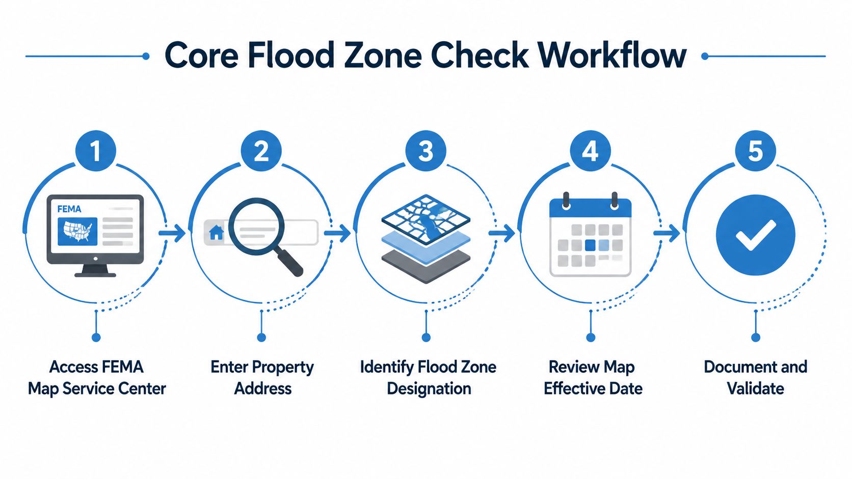
The core workflow is a map-and-model process, not a quick address lookup. FEMA guidance and mapping practice start with the correct map panel, the parcel location on that panel, and the zone code in the legend. The best practice is to verify the property against the map, not to assume the first result is enough. FEMA and related mapping references describe this as a standardized, data-driven public function built around FIRMs and searchable tools rather than local guesswork. The flood zone mapping overview from the Environment Agency shows the same broader shift from static paper maps to searchable datasets.
The sequence that prevents bad calls
- Find the correct FIRM panel. Wrong panel, wrong answer.
- Locate the parcel on the map. Address matching alone can miss parcel shape, offsets, or adjacent frontage.
- Read the zone from the legend and scale. The zone code only matters if the parcel is placed correctly.
- Check the effective date and revisions. A stale map creates stale decisions.
- Document what you used. A determination without traceability is a future problem.
The flood zone determination workflow note is useful context here because it reflects what operational teams need, not just what map readers want to see.
Where files go wrong
The most common failure points are boring, and that's exactly why they're dangerous. Someone keys the wrong parcel. Someone uses an outdated map printout. Someone assumes a boundary line is precise when it's only approximate at the map scale.
Operational truth: if the file is near a boundary, the map is only one input. You need the parcel location, the map revision date, and a clear record of why the zone assignment held.
For difficult cases, the map panel is only the start. FIRMettes, elevation certificates, and local floodplain contacts can tighten the call, especially when the zone label and the ground conditions don't seem to line up.
A short reference video can be useful for training new staff on the mechanics of the check.
How Do You Handle Coastal and Transitional Zone Complexity
Coastal and transitional properties are where simple address lookup starts failing. FEMA's own guidance says you need to identify the Base Flood Elevation, compare it with Total Water Level where available, and use surveyed topographic data to draw the A/X boundary. That makes the work elevation-driven, not label-driven. In borderline cases, the parcel's ground level, the map scale, and the surrounding terrain matter more than the zone letter on the page. Massachusetts' FEMA map interpretation guide is useful here because it shows how boundary interpretation depends on surveyed data and topography.
Why the coastline is harder
Coastal files often sit in the space between map certainty and physical reality. FEMA notes that Total Water Level isn't available for all coastal communities, so the analyst may have to work with incomplete information. That means you need to lean on the best available elevation source, not on a neat one-line result from a search box.
Riverine Zone A determinations are also technically sensitive. FEMA's method relies on cross sections from a topographic map or field survey, Manning's roughness coefficients, and discharge-versus-elevation calculations to derive the BFE. FEMA's approximate Zone A guide also notes that BFEs are interpolated from contour lines and that adding one-half of the map contour interval to the lower contour is part of the estimate. FEMA's approximate Zone A guide makes clear that survey quality affects the answer.
What to do when the data is thin
Use the best elevation source you have, then validate it against the map boundary and the local terrain. If the property is sitting close to the zone line, the decision should be treated as a boundary problem, not a lookup problem. That is where survey-grade data can change the result, especially on lots with uneven grade or altered drainage.
The file discipline that helps most is straightforward:
- Compare elevation to the zone threshold.
- Confirm whether the map revision changed the boundary.
- Ask local floodplain staff when the map and ground condition disagree.
- Escalate borderline coastal files for manual review.
The BatchData GIS data layers overview is relevant because layered geography is often the only practical way to see how parcel shape, elevation, and hazard context fit together. Static zone labels can lag behind present-day exposure when rainfall patterns, drainage failures, or sea-level conditions shift faster than map updates.
Is Manual or Automated Flood Zone Determination Better at Scale
Manual and automated determinations solve different problems. Manual review is stronger when the file is complex, disputed, or legally sensitive. Automation is stronger when you need consistent screening across a large portfolio and you can accept that some files still need human review. The right answer is usually a hybrid, not an ideology.
| Factor | Manual Approach | Automated Approach |
|---|---|---|
| Best use case | Coastal edge cases, revisions, LOMA or LOMR review, disputed boundaries | High-volume screening, first-pass risk triage, portfolio monitoring |
| Speed | Slower, but more context-aware | Fast, especially for batch processing |
| Precision | Strong when a specialist checks maps, elevations, and local context | Strong when coordinates and source data are clean |
| Weak point | Hard to scale without adding staff and review time | Can miss recent revisions or boundary nuance |
| Data quality control | Human validation and document review | API checks, coordinate validation, revision-date checks |
| Compliance posture | Easier to defend on hard cases | Easier to standardize at volume, but needs override rules |
Manual review makes sense when the property is near a boundary, when the map has recently changed, or when the file is being challenged through LOMA or LOMR processes. It also makes sense when the parcel geometry, survey data, or topography doesn't fit a clean automated rule.
Automation makes sense when the business needs repeatable screening. That includes mortgage pipelines, insurance intake, investor due diligence, and platform-level user experiences that need a quick read before deeper review. The catch is that automation only works if the coordinates are right and the map currency is checked before the zone is shown to users.
Decision rule: automate the first pass, then route boundary cases, stale-map flags, and disputed files into human review.
For teams building product or workflow layers, BatchData's APIs for hazard risk integration are one example of how flood-related screening can sit inside a broader property data workflow rather than living in a separate tool. The value is in context, not just in a zone label.
How Should You Build Operational SOPs for Your Organization
A good SOP turns flood zone determination from a one-off task into a controlled process. The exact workflow should change by business line, but the core controls stay the same, source traceability, escalation rules, and auditability. The point is to stop treating flood checks like a checkbox and start treating them like a managed decision.
What lenders and servicers need
Lenders need a file process that ties the determination to the loan record, the map source, and the compliance note. If the property sits in an SFHA, the file should show who reviewed it, what map version was used, and how the insurance requirement was communicated. Disputed determinations need an escalation path, not a debate in an email thread.
What insurers and investors need
Insurance teams need the determination integrated with the rest of the risk picture, especially when the property sits in a transitional zone or near changing terrain. Investors need a review step that looks at flood exposure during due diligence, then keeps watching for map changes or portfolio concentration over time. Neither group can rely on a single point-in-time label and call it done.
What proptech platforms need
Platforms need a data freshness rule, a display rule, and an override rule. If the property-level result is borderline, the product should show that the result depends on boundary interpretation or elevation data, not present the zone as absolute truth. Users trust tools that explain uncertainty better than tools that overstate precision.
SOP standard: every determination file should be reproducible. If another analyst can't see the same inputs and reach the same conclusion, the process isn't tight enough.
A practical SOP also includes training, spot checks, and a clear handoff to a subject matter expert when the file stops being routine. That's how teams keep speed without letting quality drift.
How Do You Move Beyond Static Zone Labels
Static FEMA zones remain the regulatory anchor, but they're only a snapshot. They don't automatically capture changing drainage, infrastructure shifts, or future-condition risk, which is why some files deserve more than a zone read. FEMA's homeowner guidance still uses the A, V, and X framework, but operational teams should recognize that the map label isn't the same thing as the full hazard picture. FEMA's homeowners flood maps guidance is the reminder that the public-facing zone story is still a simplified version of the underlying risk problem.
The better approach is layered. Use the FEMA determination, then add parcel-level elevation, drainage context, and any local data that helps explain what water can reach. That doesn't replace compliance work, it sharpens it.
Three controls make the enhanced approach workable:
- Integrate multiple sources so the file doesn't depend on one map or one screen.
- Set escalation thresholds for boundary cases, coastal files, and recent revisions.
- Explain uncertainty clearly so borrowers, policyholders, and internal stakeholders know what the result does and doesn't prove.
The business case is plain. Better risk assessment means fewer surprises, tighter pricing, and fewer post-close disputes. It also means fewer bad assumptions baked into portfolio models and user-facing tools.
Audit your current flood determination process now. Find the files that rely on stale maps, weak boundary checks, or no escalation path, then build a roadmap that balances compliance, speed, and data quality.
BatchData helps teams operationalize property-level risk data, including flood-related screening, inside lending, insurance, and proptech workflows. If you need a system that combines property attributes, ownership context, and hazard signals in one place, visit BatchData and review how its data APIs and bulk delivery options can fit your flood determination process.