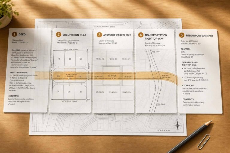
If I want to check easements before closing, I don’t stop at the deed. I use five record types together: deeds, plats, assessor records, agency right-of-way files, and later court or recording updates. That matters because an easement can affect where I can build, whether I have legal access, and whether a lender or permit office flags the property.
Here’s the short version:
- Deeds and easement agreements tell me what right was granted
- Plats and right-of-way maps show where that right sits on the land
- Assessor records help me find the parcel by APN
- Agency records help me check public roads, utility lines, and corridors
- Title history, judgments, and releases show whether the easement changed or ended
A few facts stand out:
- A title search often costs about $200 to $500
- Utility easements on plats are often 5 to 10 feet wide
- GIS and assessor maps are not survey-grade proof
- Older documents can matter just as much as the current deed
Before I search, I gather the APN, legal description, owner names, and any book/page or instrument number from Schedule B in the title policy. That usually saves time and cuts down on missed records.
How to Identify Easements and Understand Them (Title Search Tutorial)
Quick Comparison
| Record Type | What I Use It For | Main Limitation |
|---|---|---|
| Deeds & Easement Agreements | Read the legal terms of the easement | May miss unrecorded claims |
| Plats & ROW Maps | See the easement on the parcel | May not show later changes |
| Assessor Records | Find the APN and parcel trail | Not legal boundary proof |
| Agency ROW & Utility Records | Check roads, utilities, and built lines | GIS can be approximate |
| Title History & Judgments | Find releases, lawsuits, and later changes | Older indexing can be messy |
Bottom line: if I rely on just one record set, I can miss a problem. If I cross-check all five, I get a much better read on what the right is, where it runs, and whether it still applies.
What to Gather Before You Search
A little prep work can save you a lot of wasted time.
To find recorded easements faster, gather the APN, legal description, owner names, and subdivision or tract name before you start. Begin with the APN whenever you can. County databases often handle street addresses inconsistently, so an address search can send you down a dead end.
Next, look through your title documents for direct recording references. If you have title insurance, check Schedule B for the book-and-page or instrument numbers tied to recorded easements. That’s often the fastest path to the exact document.
You’ll also want to confirm the correct county and state before searching. That sounds basic, but it matters. Records are filed at the local level, and searching the wrong county is an easy way to burn time.
Use this checklist in that order:
| Identifier | Where to Find It | Why It Matters |
|---|---|---|
| APN / Parcel ID | Tax bill or County Assessor website | Primary search key for most county databases |
| Legal Description | Property deed or plat map | Defines exact boundaries, including lot/block and subdivision details |
| Recording Reference | Title policy (Schedule B) | Provides the book-and-page or instrument number to pull original documents |
| Prior Owner Names | Older deeds | Easements may appear in older instruments, not the current deed |
| Subdivision/Tract Info | Plat map or Planning Department | Helps identify neighborhood-wide utility and drainage easements |
Easement records are often split across deeds, plats, and older instruments. So don’t rely on just one source. Cross-check what you find before moving to the five record types below.
1. Deeds and Recorded Easement Agreements
Start with the recorded instrument itself. It’s the clearest proof of an express easement.
Primary Custodian or Source
Recorded deeds and easement agreements are the most direct proof of express easements. In most cases, they’re filed with the county land records office. If the record is older, you may need to visit in person or request a copy by mail.
After you find the filing, read it closely. The document should spell out the exact rights, location, and limits.
What This Record Type Reveals
A recorded deed or easement agreement identifies the grantor and grantee and states the allowed use. It also sets out the easement’s width and location on the parcel, often with a metes-and-bounds description. In some cases, it also states the term and assigns maintenance or cost-sharing duties.
| Detail Type | What’s Typically Disclosed |
|---|---|
| Parties | Names of the Grantor and Grantee |
| Purpose | Specific use (e.g., utility, access, drainage, conservation) |
| Dimensions | Precise width, depth, and location on the parcel |
| Maintenance | Repair duties and cost-sharing assignments |
| Term | Perpetual or fixed-term duration |
| Restrictions | Prohibitions on structures within the easement zone |
If the deed feels vague, check plats and parcel maps to pin down where the easement sits.
Best Research Use Case
Deeds and recorded agreements are the best place to begin for pre-purchase due diligence. This source is the clearest way to spot express easements created by written agreement and binding on later owners. If you need an independent title search, it usually costs $200–$500.
Use this record type to confirm the exact wording, scope, and limits of the easement before you compare it with plats and assessor data.
Common Limitations and Gaps
The main blind spot is simple: recorded documents only show express easements. They do not show prescriptive easements or easements by necessity, which can exist outside the written record.
There are other gaps too. Some documents use loose wording, like “the western 10 feet,” which can spark fights over the exact physical location. An easement may have expired or been abandoned, but the original document can still sit in the public record with no release ever filed. Older filings can also point to missing exhibits or maps.
Because this source only reflects recorded agreements, pair it with plats and agency records. That helps you catch missing pieces, abandoned rights, or claims that were never recorded. Plats and later filings can also show whether the easement was changed, released, or never fully recorded.
2. Subdivision Plats, Parcel Maps, and Right-of-Way Maps
After you find the recorded easement, the next step is to use the plat to place it on the parcel.
Primary Custodian or Source
Official plats and right-of-way maps are usually recorded with the County Recorder, Register of Deeds, or County Clerk. You can also check a few support sources:
- The County Assessor’s Office for tax parcel maps
- The local Planning and Zoning Department for preliminary plats and conditions of approval
- Public Works departments for right-of-way details
GIS portals can help you get your bearings, but they should only be used to orient the search.
If the deed includes a plat book and page number, use that first. It can save a lot of time when tracking down the recorded map.
What This Record Type Reveals
Plats take a recorded right and turn it into something you can actually place on the ground. Subdivision plats show lot and block numbers, exact boundary dimensions, and the location of Public Utility Easements, Drainage Easements, access strips, and building setback lines. Utility easement areas are often shown as 5 to 10 feet wide.
Right-of-way maps, often kept by the local Public Works department, show road corridor limits and utility corridors tied to municipal infrastructure. The legend matters here. Dashed lines usually mark easements or setbacks, while solid lines show lot boundaries.
Once the map pins down the location, use assessor and land records to confirm the parcel trail with enriched property data.
Best Research Use Case
These maps are most helpful when you need to confirm lot dimensions and spot recorded easements before permit applications. This is the point where you check whether an easement cuts into a buildable area, driveway, or setback. If you’re dealing with road widening or encroachment questions, a right-of-way map can also show where the corridor actually stops.
For digital plats, use the graphic scale bar. It stays accurate even if the image has been resized.
Use plats before filing for fences, pools, additions, or road-adjacent work.
Common Limitations and Gaps
Plats show the recorded design, not later title changes or unrecorded rights. They also won’t show later site changes. And they do not reveal prescriptive easements or easements by necessity, because those are not shown in the recorded plat itself.
A common gap comes up with older or unplatted parcels. If a parcel was never part of a formal subdivision, there may be no plat at all. In that case, the boundaries usually depend on a metes-and-bounds deed description instead.
For legal or construction decisions, use the recorded final plat. Treat GIS overlays as reference only. For more reliable results, developers can integrate real estate data APIs to access verified property records directly.
3. County Assessor Parcel Records and Land Records
Once plats help you pin down the location, assessor parcel records give you the APN and parcel facts you need to track down the recorded easement or right-of-way in county land records. From there, you can use the APN to pull the deed, easement agreement, or subdivision plat tied to that parcel.
Primary Custodian or Source
These records are usually kept by the County Assessor. In many counties, you can also get them through the Recorder, Register of Deeds, or County Clerk using an assessor parcel viewer or land records portal.
What This Record Type Reveals
Think of assessor records as an index, not proof. They don’t prove that an easement exists. What they do is help you find the parcel and connect it to recorded documents. That usually means the APN, parcel dimensions, and assessed acreage, which is often enough to match a location to the right recording trail.
In many counties, right-of-way acreage is taken out of the assessed parcel when land is dedicated or condemned.
Best Research Use Case
Use assessor records as your starting point, not your last stop. First, find the APN. Then use it to pull the deeds, easement agreements, or subdivision plats linked to that parcel from the County Recorder’s office. Assessor data also helps you confirm you have the right parcel before you check public agency right-of-way records.
Common Limitations and Gaps
The Alameda County Assessor states it plainly:
"Assessor parcel maps are prepared for assessment purposes only. They are not legal surveys and should not be used to determine exact property boundaries or resolve boundary disputes."
Private easements are a common blind spot. Why? They often don’t change taxable land size, so many assessors don’t track them. If you’re making construction or title decisions, check assessor data against recorded deeds, plats, or a licensed survey.
4. Public Agency Right-of-Way and Utility Easement Records
After you confirm the parcel and pull the recorded deed or plat, the next stop is public agency records. This is where you figure out what rights government bodies and utility providers hold in the land, and where those rights actually run. Put simply, these records help you check whether the legal rights shown on paper line up with what was built in the field.
Primary Custodian or Source
These records are usually spread across a few places:
- State DOTs
- County and city public works departments
- Utility owners
- Utility-location services
- GIS portals published by public agencies
That split matters. You may need to check more than one source to get the full picture.
What This Record Type Reveals
Public agency records are often the best place to verify utility- or government-held easements – meaning easements that benefit a named entity, like a utility company, instead of a neighboring parcel.
When the file is well documented, it can show:
- The corridor’s exact boundaries, width, and centerline
- The easement’s purpose, such as water, sewer, electric, gas, telecom, or drainage
- The easement holder
- The part of the private parcel affected
As-built plans add another layer. They show where utilities were actually installed, which does not always match the recorded easement.
A right-of-way grants use rights, not ownership rights.
Best Research Use Case
These records matter most before any construction in or near a utility corridor. Build inside an easement and the project can run into redesigns, permit delays, or even removal work. That’s the kind of problem no one wants to find after crews are ready to dig.
A practical way to start is with 811 for approximate buried-line locations, then compare those results with the recorded documents.
For state highway corridors, it’s smart to contact the District right-of-way or survey records office directly. Many as-built plans are not fully digitized, so an online portal search by itself can miss key records. If what the agency has on file doesn’t match the deed or plat, the next move is to check later recorded instruments.
Common Limitations and Gaps
GIS data is approximate, not survey-grade. That’s a big distinction. It can point you in the right direction, but it should not be treated like a final boundary call.
Rural water authorities and railroad corridors may also be missing from standard 811 searches, so those owners should be contacted directly. It helps to read these records alongside title history and supplemental recorded instruments to confirm whether an easement was changed, moved, or released.
5. Title History, Judgments, and Supplemental Recorded Instruments
Even after you pull deeds, plats, and agency records, holes can still show up. That’s where title history, judgments, and related filings come in. Think of this as the cleanup pass: the step you take when the chain of title breaks, earlier records clash, or an easement’s status just isn’t clear.
Primary Custodian or Source
Most of these records sit with the County Recorder, Register of Deeds, or County Clerk. If the issue involves a lawsuit or court order, go to the Clerk of Court instead. A title policy’s Schedule B can also help by pointing you to releases, amendments, or judgments by instrument number.
What This Record Type Reveals
Deeds and plats usually show the original grant. These records show what happened after that. And that matters, because some easement changes appear only in later filings.
This record type can reveal:
- Releases confirming an easement was legally extinguished
- Amendments that changed an easement’s width, location, permitted use, or maintenance duties
- Court judgments establishing or resolving easements by necessity or prescription
- Lis pendens filings showing active litigation over access or property rights
- Condemnation records from eminent domain proceedings
Best Research Use Case
This record type helps most when the chain of title has a break, or when the property passed through probate, divorce, foreclosure, or another court process and the easement trail goes cold. In those cases, court records may show whether a quiet title action settled competing claims.
It also helps when an old easement appears in a deed, but you can’t find any later document showing a release or amendment. When that happens, trace the recorded history with care and check whether the instrument is still in force.
Common Limitations and Gaps
Prescriptive easements may not appear in the public record unless and until a court enters judgment.
Indexing can also be messy. Some counties record easements under the burdened parcel, while others file them under the benefiting parcel. So a basic name search may miss the document completely. Older court files may also be purged or moved to off-site archives, which can slow retrieval. Search every name variation that could exist, because one spelling mistake can bury the record in the index.
Next, compare these record types side by side to check whether the easement still exists, changed, or ended.
How to Use These 5 Record Types Together
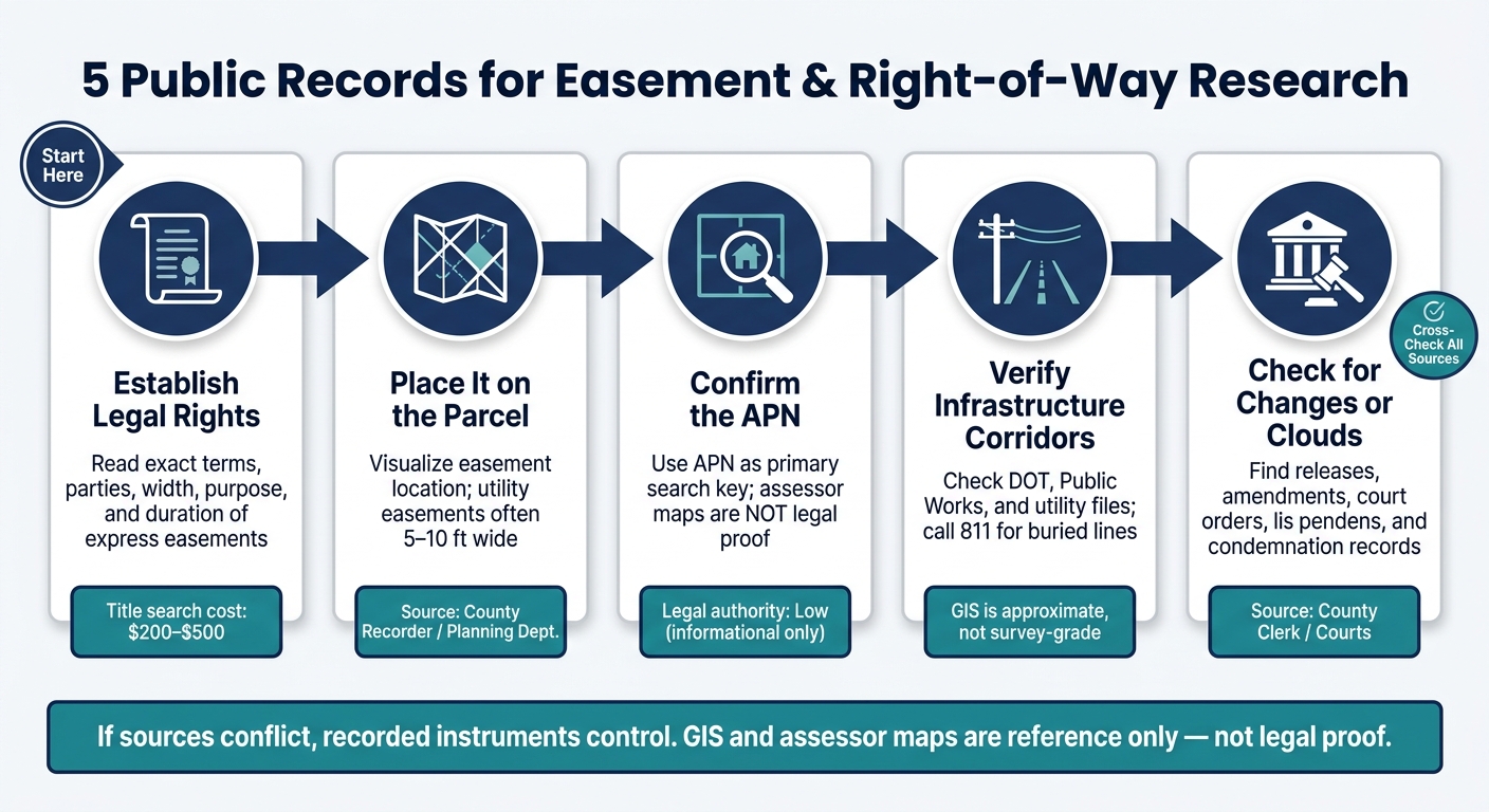
5 Public Records for Easement Research: Step-by-Step Workflow
No single record type does the whole job.
Deeds create the right. Plats show where that right sits on the parcel. Assessor records confirm the APN. Agency files show public infrastructure. Later filings show whether the easement still exists. Used in that order, these records help close the gaps that can pop up when you rely on just one source.
Start the search like this:
- deed
- plat
- assessor record
- agency file
- later amendments, releases, or judgments
After that, check source priority.
If sources conflict, recorded instruments control. That matters a lot. A GIS layer may point you in the right direction, but it doesn’t settle the issue.
For multi-county searches, BatchData – Ivo Draginov can help normalize APNs, names, and addresses across parcel records and recorded instruments. That can save a lot of back-and-forth when records don’t line up cleanly from one county to the next.
One more thing: GIS is approximate, not survey-grade. Use GIS and assessor data to find records, not to resolve disputes.
The quick comparison below shows how each record type differs in source, use, and reliability.
Quick Comparison of the 5 Record Types
Not all property records do the same job.
Some carry strong legal weight. Others are mainly there to help you spot a parcel, find an APN, or get a rough sense of where an easement might sit. That distinction matters. It can save time, and it can stop someone from treating an assessor map like legal proof.
Here’s the side-by-side view:
| Record Type | Typical Custodian | Legal Authority | Spatial Precision | Typical Details | Best Use Case |
|---|---|---|---|---|---|
| Deeds & Easement Agreements | County Recorder / Register of Deeds | High (Express/Contractual) | Low to Moderate (Textual descriptions) | Grantor/grantee, purpose, width, and duration of express easements | Establishing primary legal rights and specific terms |
| Subdivision Plats & Parcel Maps | County Recorder / Planning Dept. | High (Recorded plat) | High (Recorded dimensions) | Utility corridors, shared driveways, and road widths for entire blocks | Visualizing how easements fit within a neighborhood layout |
| Assessor Records & GIS Maps | County Assessor / State Land Portals | Low (Informational only) | Moderate (Approximate overlays) | Parcel boundaries, APN, and approximate easement overlays | Quick visual identification and finding the APN for research |
| Public Agency ROW & Utility Records | Public Works / DOT / Utility Co. | High (Regulatory/Operational) | High (Engineering/Infrastructure) | Sewer/water mains, public road ROW, and maintenance access corridors | Verifying actual utility locations and public access rights |
| Title History & Judgments | Title policy / County Clerk / Courts | High (Judicial) | Varies (Legal findings) | Court orders, easements by necessity, and unreleased claims | Uncovering litigated access rights or clearing title clouds |
Use the table to match the record type to the question you’re trying to answer. Then move to the common pitfalls below.
Common Mistakes in Easement and Right-of-Way Research
Even if you look at the right records, a few missteps can throw the whole search off.
First, don’t treat assessor maps or GIS maps as legal proof. They’re useful for getting your bearings and seeing the general layout of a parcel, but that’s it. Think of them as a guide, not the final word.
Another common mistake is stopping with the current deed. That sounds sensible, but it can leave out a lot. Easements often stay in force because of older recorded instruments, so you need to check prior title documents too. A right that was recorded years ago doesn’t disappear just because it’s not spelled out in the latest deed.
It also helps to separate what you can see from what the record shows. A driveway, lane, or footpath may show that people have been using an area, but visible access is not the same as recorded legal access. Use can suggest a claim or history, but it does not, by itself, prove an easement.
You’ll also want to look for changes after the original grant. That means checking for recorded releases, amendments, relocations, and abandonments. On top of that, verify utility and roadway corridors in the files kept by the right agency. If you skip that step, you can miss a corridor that matters to the parcel.
One more trap: relying on one file set to tell the whole story. It won’t. No single record type gives you the full easement or right-of-way picture. Utility easements, public road right-of-way, drainage corridors, and sewer lines may be spread across deeds, plats, and separate agency records. In plain terms, the paper trail is often scattered.
For high-stakes parcels, it’s smart to order an ALTA/NSPS Land Title Survey. That can help flag unrecorded use that the public record alone may not show.
Conclusion
These records work best as a set. Together, they answer three basic questions: what the right is, where it sits, and whether it still applies. No single record tells the whole story of an easement or right-of-way. Deeds, plats, assessor data, agency files, and later filings need to be read together, not one by one.
To move fast, start with the APN. Pull the current deed and the title commitment Schedule B, Section II to spot recorded exceptions. From there, trace the matching deed, plat, and agency record. Cross-check subdivision plats and county GIS maps to see how those rights line up with parcel boundaries. Then review agency records and contact 811 to flag infrastructure corridors that may not show up in the deed.
Miss an easement before a purchase, and the cost can hit hard: legal fees, lost property value, or even forced structure removal. Used together, these records give buyers and lenders the clearest pre-closing view of access rights.
FAQs
How do I know which county to search?
Search the county where the property sits. Property records are stored locally, usually by the County Recorder, Register of Deeds, or County Clerk.
To make sure you have the right county, check your property tax bill, mortgage papers, or deed. Then go to that county’s official website, or visit the office in person, and search using your Assessor’s Parcel Number or legal description.
What if the easement is not on the current deed?
It may still be a legally binding interest in the property. In many cases, easements are recorded separately from the main deed. You might find them in utility agreements, access grants, plats, subdivision maps, or standalone easement agreements.
Some easements aren’t recorded at all. That often happens when they come from long-term past use, necessity, or prescription. If you think there may be an unrecorded right-of-way, check the property’s past use, look at aerial imagery, or ask a surveyor to inspect the site.
When should I order a survey?
Order a professional survey when you need to turn the legal description in a deed or plat map into an exact, on-the-ground map of the property.
This matters most before you buy, before major construction, when easement language is vague, or when you think encroachments or hidden claims might cut into your buildable area.