



Zoning isn't primarily a legal-reading problem for real estate teams. It's a data standardization problem. Municipal rules determine what can be built, where it can sit, and how intensely a parcel can be used, yet those rules are fragmented across maps, ordinances, amendments, planning documents, permit records, and administrative decisions.
A workable zoning and land use workflow converts that scattered material into structured attributes, preserves the source language, and separates permitted capacity from realized development potential. It also connects regulatory data with parcel geometry, ownership, permits, liens, and market signals so analysts can underwrite an opportunity rather than merely label a zoning district.
- Zoning codes describe enforceable uses and dimensional controls.
- Overall plans establish long-range policy direction.
- Setbacks and FAR translate code into site-level buildability.
- Variances and conditional uses create different entitlement pathways.
- Standardized datasets and APIs make jurisdiction-by-jurisdiction analysis scalable.
The practical question is no longer just what a parcel is zoned for. It's whether a team can measure the rule consistently, validate it, and connect it to an investable decision.
Why Zoning and Land Use Data Remains Fragmented
The popular advice is to “check the zoning.” That advice is incomplete. A zoning label rarely answers the investment question by itself, because the relevant evidence may be distributed across a zoning map, a municipal code, overlay rules, a general plan, parcel geometry, permit history, and recent amendments.
Zoning is highly local and often published in formats designed for human interpretation rather than machine processing. A code may use a district abbreviation, while a map uses a different field name and a planning document describes the same area through a future land-use category. A scraped label can therefore look precise while omitting the dimensional or procedural rule that controls feasibility.
The national zoning database built with natural language processing exists for this reason. Researchers describe zoning as fragmented, local, and difficult to compare at scale, and the dataset converts publicly available administrative rules into more comparable records. The hard part isn't collecting a string called “zoning.” It's preserving meaning across jurisdictions.
Practical rule: Treat a zoning record as an evidence package, not a single field.
Why labels fail in portfolio analysis
A portfolio team asking “how restrictive is this market?” needs more than district names. It needs normalized attributes such as:
- Allowed uses: Residential, commercial, industrial, agricultural, mixed-use, or prohibited categories.
- Intensity controls: Density limits, FAR, height, lot coverage, and minimum lot dimensions.
- Placement rules: Front, side, and rear setbacks, parking, access, and easements.
- Process requirements: By-right approval, special review, conditional use, variance, or rezoning.
- Change indicators: Ordinance amendments, overlay adoption, plan updates, and permit activity.
For a vacant parcel, even an introductory resource on residential zoning for vacant lots is more useful when paired with local code verification. General guidance can frame the question, but it can't substitute for the controlling ordinance and parcel-specific constraints.
The infrastructure response
A scalable workflow needs a canonical schema, jurisdiction-specific source tracking, geometry joins, and an update process. GIS layers help connect zoning polygons to parcels, boundaries, roads, flood areas, and other physical constraints. A useful reference for that spatial foundation is GIS data layers for property analysis.
Natural language processing can extract candidate attributes from ordinances, but automated extraction shouldn't erase ambiguity. Store the original text, effective date, source document, confidence score, and human review status beside every normalized value. That design lets an analyst distinguish “not allowed,” “not found,” and “requires confirmation,” which are materially different underwriting outcomes.
How Comprehensive Plans Dictate Zoning Ordinances
A thorough plan is the policy blueprint, while a zoning ordinance is the regulatory instrument that implements that direction through enforceable districts and standards. Treating them as interchangeable creates avoidable entitlement risk.
New York guidance explains that local zoning laws must be adopted in accordance with a general plan. The same guidance distinguishes the plan from the zoning code and states that zoning regulates land use, density, and the siting of development. That hierarchy matters because a plan can support a desired future pattern without granting a present right to build it.
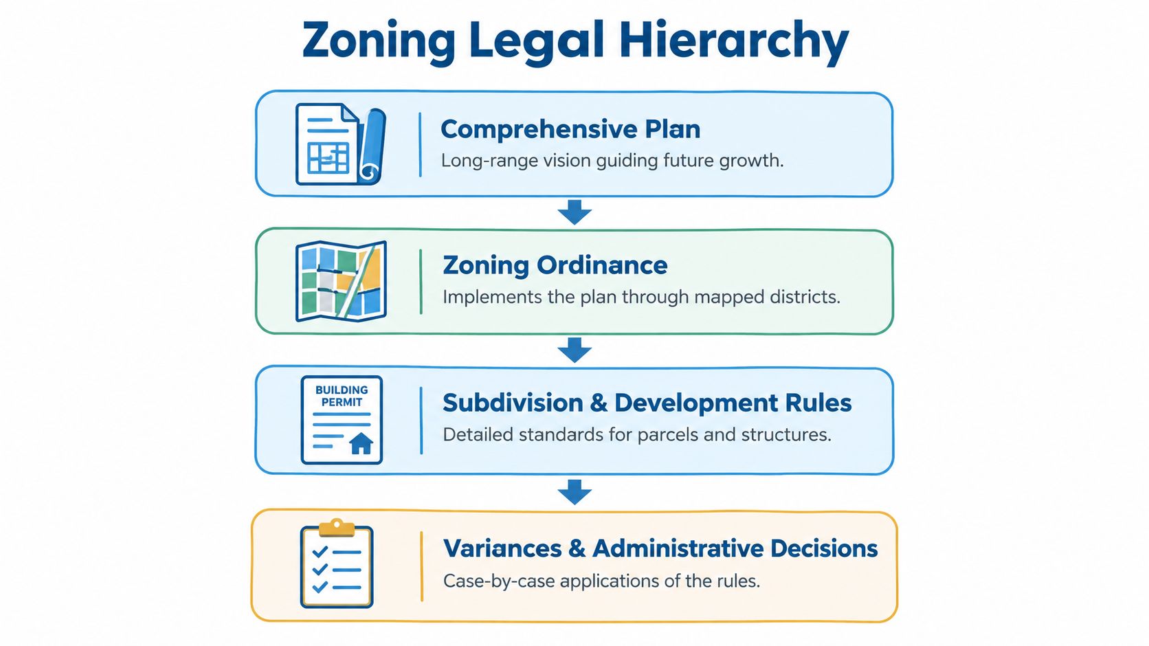
The hierarchy in practice
- Comprehensive plan: Establishes long-range growth, land-use, infrastructure, and development objectives.
- Zoning ordinance: Maps those objectives into districts and writes enforceable use and dimensional standards.
- Subdivision and development rules: Apply detailed parcel and structure requirements, including access, frontage, drainage, and site design.
- Administrative decisions: Resolve project-specific applications through permits, variances, conditional uses, and other review actions.
The plan therefore answers, “What development pattern does the jurisdiction intend to pursue?” The ordinance answers, “What may an owner legally do under the current code?” An investor who sees a future mixed-use designation but fails to check the current district may overstate near-term capacity. A servicer who relies only on the zoning map may miss a policy conflict that affects rezoning risk.
What to capture in a data model
Store the plan and ordinance as related but separate objects. Useful fields include:
| Record | What it tells the analyst | Underwriting use |
|---|---|---|
| Comprehensive plan | Intended long-term land-use direction | Rezoning and policy alignment |
| Zoning ordinance | Current enforceable uses and standards | Present development rights |
| Future land-use map | Spatial expression of policy goals | Market transition signals |
| Administrative decision | How officials applied the rules | Entitlement and precedent review |
A plan doesn't automatically change a parcel's legal entitlement. The current ordinance, adopted amendments, overlays, and applicable procedures still control the immediate decision. That distinction should appear directly in property profiles, analyst notes, and automated investment screens.
Calculating Buildable Area Using Setbacks and FAR
Setbacks control where a structure can sit, while FAR controls how much floor area can be built. They're related constraints, but they shouldn't be collapsed into one “buildable” field.
A setback is the minimum horizontal distance from a property line to a structure, parking area, or another regulated feature. It's measured horizontally at right angles to the property line. If a parcel abuts a street with a required dedication or easement, the measurement begins at the dedication or easement line rather than the original street edge, which can change the usable envelope.
Floor area ratio, or FAR, equals gross floor area divided by net lot or parcel area. The formula is:
FAR = Gross Floor Area ÷ Net Lot Area
A parcel can therefore satisfy its FAR limit while failing its setback envelope, or fit inside its setbacks while exceeding its permitted floor area.
| Control Lever | Definition | Calculation / Measurement Rule | Impact on Feasibility |
|---|---|---|---|
| Setback | Minimum horizontal distance from a property boundary to a regulated feature | Measure at right angles to the property line, or from the dedication/easement line where applicable | Shrinks or shifts the buildable envelope |
| FAR | Ratio of gross floor area to site area | Gross floor area divided by net lot or parcel area | Caps total building bulk and intensity |
| FAR bonus | Additional permitted floor area tied to specified site conditions or design choices | Apply the ordinance's bonus to the base FAR or add the stated premium | Can improve capacity when public-policy conditions are satisfied |
A parcel-level calculation sequence
Start with a clean parcel boundary, then identify the controlling lot area. Don't calculate from an approximate map screenshot when an easement, dedication, subdivision line, or boundary correction can alter the result.
Next, map the required setbacks. The result is a two-dimensional envelope that shows where a structure may be placed. Parking and other regulated features may have separate standards, so a building envelope isn't necessarily a complete site plan.
Then calculate the base FAR and compare it with the envelope's physical ability to accommodate that floor area. A zoning code can permit substantial theoretical floor area while setbacks, access, parking, utilities, topography, or construction economics prevent full utilization.
Digital boundary workflows, including geolocation APIs for property boundaries, can support this geometry step, but the API output still needs validation against the municipality's authoritative parcel and zoning records.
Bonuses are arithmetic, not assumptions
One planning reference gives concrete examples of how a code can modify FAR. If a zoning lot adjoins public open space of at least five acres and at least 200 feet deep, the FAR may increase by 15%. If the first story above grade is set back at least 20 feet from a public street across the full frontage, a premium of 1.5 for each such street may be added to permissible FAR, subject to the applicable rule.
Those provisions shouldn't be modeled as automatic upside. Each bonus requires a site condition, design choice, and code interpretation. Store the base entitlement, qualifying condition, bonus formula, and approval status as separate fields.
Navigating Variances Versus Conditional Uses
A variance changes the application of a dimensional rule, while a conditional use authorizes a generally compatible use after special review. They're different legal and underwriting pathways, and confusing them can lead a team to pursue an unavailable remedy.
A variance typically addresses practical difficulties created by strict dimensional standards, such as setbacks or height limits. It can't authorize a use that the zoning district prohibits. A conditional use, by contrast, is generally compatible with the district but requires a permit because site-specific concerns need review.
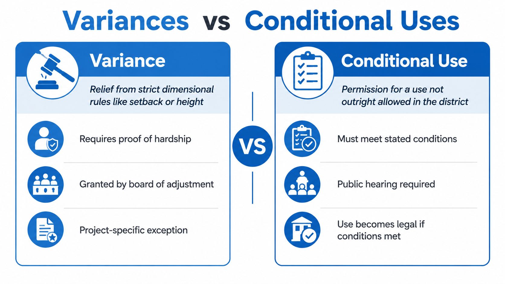
| Decision path | What it addresses | Typical issue | Core risk |
|---|---|---|---|
| Variance | Relief from strict dimensional standards | Setback, height, or similar physical constraint | The requested deviation may lack the required practical-difficulty showing |
| Conditional use | Permission for a use requiring site-specific scrutiny | A compatible use with traffic, hazard, location, or operational concerns | The use may fail one or more ordinance conditions |
| Rezoning | Change to the district or permitted use framework | A prohibited or fundamentally inconsistent use | Policy conflict, political opposition, and extended review |
How the burden differs
For a variance, the applicant generally must show that applying the rule creates a practical difficulty tied to the property. The request should be narrowly framed around the dimensional obstacle. Asking for a variance to permit a prohibited use is the wrong pathway.
For a conditional use, the applicant must meet the standards written into the ordinance and address the concerns that justify special review. The use isn't necessarily unlawful in the district. It becomes permissible only after the applicant satisfies the required conditions and obtains the relevant approval.
That distinction changes how an analyst should classify an opportunity. A dimensional problem may be an exception risk. A prohibited use is usually a use entitlement problem. A conditional use is a standards-and-process problem.
What to document before underwriting
- District status: Is the proposed use prohibited, permitted, or conditionally permitted?
- Dimensional conflict: Which setback, height, lot, or bulk rule creates the issue?
- Approval body: Which board or official reviews the application?
- Proof standard: What facts must the applicant establish?
- Conditions: What design, access, safety, operating, or mitigation requirements apply?
- Precedent: How has the jurisdiction handled comparable applications?
Municipal zoning guidance emphasizes that applicants carry the burden of showing compliance with the relevant standards. A clean data model should retain the application type, decision date, conditions, findings, and supporting documents rather than reducing the outcome to “approved” or “denied.”
Measuring the Market Impact of Land Use Regulations
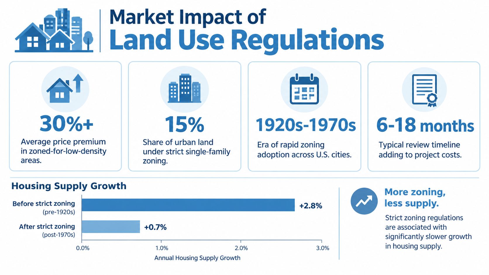
Zoning has market consequences because it limits the amount, location, and intensity of development that a parcel can support. The effects aren't uniform, but national and historical evidence shows that regulation belongs in housing-market and portfolio models.
Zoning spread rapidly in the United States during the early twentieth century. Before 1910, the country had no zoning ordinance. By the end of 1916, eight cities had adopted zoning. By 1926, another 68 cities had done so, and by 1936, 1,246 additional municipalities had adopted zoning, covering 70% of the U.S. population. New York City adopted the first citywide zoning resolution in 1916, and the Supreme Court affirmed zoning as a valid local police power in 1926 through Village of Euclid v. Ambler Realty. These historical facts are documented in HUD User's Cityscape discussion of zoning's development.
What national data indicates
The 2019 National Longitudinal Land Use Survey covered roughly 1,700 jurisdictions and connected responses to earlier survey waves from 2003 and 1994, providing a multi-decade view of zoning practices. The Urban Institute reports that rising land-use regulation was associated with rising real home prices in 44 states, while rising zoning regulation was associated with rising real home prices in 36 states. Those associations don't mean every regulatory change produces the same price response, but they do show why land-use regulation belongs in market selection and valuation analysis. See the Urban Institute's National Longitudinal Land Use Survey data project.
Seattle offers a historical illustration of changing land composition. In a study of the city, single-family use declined from 44.7% of the sample in 1920 to 29.9% in 1952. During the same period, business use rose from 6.2% to 19.7%, while commercial use rose from 6.8% to 9.3%. The figures show that zoning and land-use decisions can reshape the composition of urban land over time, not merely annotate it.
Why permitted capacity isn't built form
Low-density zoning sets an upper bound, not a construction guarantee. An empirical study of new subdivisions in Calvert County, Maryland used GIS-coded parcel data over 34 years and found that the number of lots permitted by zoning was positive and highly significant in explaining achieved density. The study also found that some subdivisions were built below the maximum permitted density, meaning market conditions and infrastructure constraints affected realized intensity. The RFF study on subdivision density and zoning supports a critical modeling rule:
Underwriting rule: Model zoning as constrained capacity, then separately estimate the probability of realizing that capacity.
A property profile should therefore distinguish maximum permitted lots, likely achievable lots, existing built form, infrastructure readiness, and entitlement friction. Conflating those values produces inflated development screens and weak portfolio comparisons.
Analyzing Zoning Attributes with the BatchData API
A scalable zoning workflow joins normalized regulatory attributes with parcel, ownership, tax, permit, and financial data. BatchData's property data includes zoning and development fields such as zoning code, land use, FAR, and air rights, while its broader dataset covers property characteristics, ownership, valuations, mortgages, liens, permits, and related records.

A practical ingestion pattern
- Define the decision first. Decide whether the query supports infill screening, portfolio monitoring, lender review, redevelopment sourcing, or another workflow. The target decision determines which zoning and land-use attributes matter.
- Normalize the jurisdiction. Store municipality, county, state, district identifier, source document, effective date, and geometry reference. Don't treat similarly named districts in different jurisdictions as equivalent.
- Pull zoning-linked property attributes. Query location, property size, usage type, construction details, zoning fields, and permit history together. That combination makes the result useful for screening instead of producing a detached zoning list.
- Separate facts from derived scores. Keep raw zoning code and source text intact. Calculate separate indicators for intensity, by-right status, transformation potential, overlay exposure, and entitlement complexity.
- Enrich ownership and financial context. Add owner identity, equity, mortgage, lien, and contact fields only after establishing that the parcel meets the land-use criteria. This keeps lead generation connected to actual feasibility.
- Create a review queue. Route low-confidence extractions, conflicting records, recent amendments, and unusual overlays to analyst review. Automation should prioritize attention, not conceal uncertainty.
For a proptech platform, the API layer should expose filters such as land-use category, FAR range, zoning district, parcel size, permit history, and geography. For an investment team, the output should be a ranked worklist with the source and confidence behind every material attribute.
The publisher describes BatchData as providing 155M+ U.S. property records, 1,000+ attributes, low-latency APIs, and delivery through S3, Snowflake, or flat files. Those product claims should be evaluated against a team's own coverage, freshness, licensing, and source-validation requirements. The relevant design principle is broader: regulatory data becomes operational only when it can be queried alongside the property and ownership signals that drive an investment decision.
The following product walkthrough provides additional context on how property data can be exposed to analysts and applications.
Executing a Data-Driven Due Diligence Workflow
A mixed-use infill opportunity should move through due diligence as a sequence of evidence checks, not a single zoning lookup. The investment team's first task is to confirm the current district, overlays, permitted uses, dimensional standards, and any pending amendments that could change the property's development path.
The screening sequence
The team begins with Smart Property Search to isolate parcels matching the target geography, land-use category, parcel characteristics, and development signals. It then verifies the zoning record against the municipal map and ordinance, checking whether the current district supports the intended mixed-use concept by right or requires conditional review, a variance, or rezoning.
Next, analysts compare the proposed building envelope with setbacks, FAR, access, and other physical controls. They review permit history for additions, conversions, or structural changes that may not match the visible property record. An unpermitted change can affect valuation, insurance, financing, and the credibility of the seller's representations.
Ownership and financial records complete the initial risk picture. Equity, mortgage, and lien information can help the team assess refinancing pressure, title complexity, and seller motivation, but those signals should support rather than replace title and legal review.
A disciplined real estate due diligence checklist should record the source, date, reviewer, unresolved issue, and next action for every material finding. That audit trail matters when an analyst hands the opportunity to acquisitions, legal counsel, a lender, or an investment committee.
Decision standard: Don't call a parcel “developable” until the current rule, physical envelope, approval pathway, permit history, and ownership position have all been tested.
The final output shouldn't be a colorful map with unsupported upside. It should be a property record that separates verified facts from assumptions, identifies the entitlement path, quantifies the applicable capacity rules, and states what still requires municipal or legal confirmation.
BatchData combines property, zoning, ownership, permit, valuation, lien, and contact data through APIs and bulk delivery for underwriting, portfolio monitoring, and due diligence workflows. Visit BatchData to evaluate how its property search and data services can connect fragmented zoning and land-use evidence to actionable real estate analysis.