Geolocation APIs simplify property boundary validation by providing precise parcel data, ownership details, and legal descriptions. These APIs use inputs like addresses, coordinates, or parcel numbers to deliver boundary polygons in GeoJSON format, making them ideal for mapping and real estate workflows. By automating tasks like geocoding, reverse geocoding, and spatial queries, these tools save time and reduce errors in real estate processes.
Key points:
- What they do: Convert addresses or coordinates into accurate property boundaries and related data.
- Why it matters: Prevents legal disputes, improves risk assessments, and ensures compliance.
- Core features: Geocoding, parcel lookups, boundary polygons, and spatial analysis.
- Applications: MLS validation, underwriting, zoning checks, bulk address verification, and territory management.
These APIs streamline workflows, integrating boundary data with property records for better decision-making. They are fast, accurate, and scalable, but outputs should be cross-verified for legal or financial transactions.
Core Capabilities of Geolocation APIs for Boundary Validation
Geocoding and Reverse Geocoding
Geocoding and reverse geocoding are key processes when it comes to validating property boundaries. Geocoding takes a physical address and converts it into latitude and longitude coordinates, while reverse geocoding does the opposite – translating those coordinates into property-specific details such as the Assessor’s Parcel Number (APN), legal descriptions, and boundary characteristics. For boundary validation, accuracy is critical; standard geocoding often provides street-level estimates, but rooftop-level precision is necessary. To achieve this, use the locationType=rooftop parameter.
Fine-tuning results through feature filtering can make a big difference. Configuring reverse geocode requests to return only featureTypes=Parcel helps ensure the API delivers parcel-specific details rather than unrelated points of interest. Typically, parcel centroids allow for a 25-meter search tolerance, but rooftop-level PointAddress accuracy can extend up to 50 meters. These precise coordinates enable the API to generate accurate parcel boundaries.
Parcel and Boundary Polygons
Once coordinates are pinpointed, the API can return the property’s boundary as a polygon that traces the lot lines with precision. This boundary data is provided in GeoJSON format, compatible with most GIS platforms and mapping libraries. For properties with multiple disconnected areas – like a lot split by a road – the data uses MultiPolygon geometries. These detailed polygons are crucial for ensuring legal compliance and tracking property details over time.
The API also supplies additional information such as parcel dimensions, zoning classifications, and stable identifiers like ll_uuid. For faster lookups focused solely on attributes, the return_geometry=false parameter can be used to omit the geometry details.
Proximity and Spatial Queries
Spatial queries enhance boundary validation by examining how properties relate to their surroundings. A radius search, for instance, creates a circular buffer around a specific point and identifies all parcels within that distance. This is especially useful for locating neighboring properties, checking for encroachments, or assessing risks like flood zone exposure. Some APIs even support a maximum radius of 32,000 meters (roughly 19.9 miles).
Bounding box queries, on the other hand, define a rectangular area and return all parcels within it. This method works well for analyzing neighborhoods or managing larger property portfolios. Both radius and bounding box queries can also be used to cross-check spatial relationships with external datasets, such as FEMA flood zones or zoning overlays. For cases where a coordinate falls just outside a parcel boundary, applying a small radius buffer can help ensure the correct parcel is captured. These tools allow for a comprehensive understanding of each parcel within its broader geographic context.
Designing a Property Boundary Validation Workflow
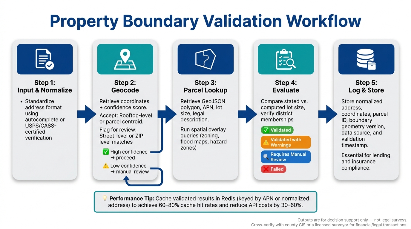
Property Boundary Validation Workflow: 5-Step API Process
Common Use Cases for Boundary Validation
Property boundary validation plays a critical role in U.S. real estate, addressing several key needs with geolocation technology.
- MLS listing validation ensures a listing’s address corresponds to an actual parcel and verifies that the stated lot size aligns with official parcel polygon data.
- Property underwriting evaluates whether a financed or insured property overlaps with hazard zones, helping classify risk more accurately.
- Bulk address verification tackles large-scale needs for institutional investors and servicers, normalizing and validating thousands – or even millions – of addresses. This process attaches identifiers like APNs (Assessor’s Parcel Numbers) and county FIPS codes while flagging properties incorrectly linked to the wrong jurisdiction.
- For developers and planners, zoning and compliance checks confirm that a project site is entirely within the correct zoning district and assess whether setbacks or easements impact the buildable area.
- Brokerages rely on territory management workflows to ensure properties fall within designated sales regions, using custom polygon boundaries for verification.
All these scenarios boil down to three essential questions: Where is the property? What are its official boundaries? How do those boundaries interact with geographic rules and potential risks?
Matching Geolocation Features to Workflow Needs
By leveraging geocoding and parcel lookup tools, workflows can be tailored to specific needs, cutting down on unnecessary expenses. Not every use case requires every geolocation feature, so aligning tools with the task at hand saves both time and money.
| Use Case | Must-Have Features | Supporting Features |
|---|---|---|
| MLS listing validation | Forward geocoding, parcel polygons | Zoning/school district overlays |
| Underwriting & risk | Parcel polygons, spatial hazard queries | Rooftop-level geocoding, historical boundaries |
| Bulk address verification | Batch geocoding, address normalization, APNs | Confidence scores, async batch endpoints |
| Zoning & compliance | Parcel polygons, spatial overlay tools | CRS transformations, line-buffer setback tools |
| Territory management | Spatial within/contains queries | Reverse geocoding for map-click interactions |
A phased approach works best here. Start with forward geocoding and parcel lookup as the foundation. Then, integrate spatial overlays and hazard intersections for risk and compliance needs. Finally, optimize for scale by adding batch endpoints and caching. Providers like BatchData simplify this process by offering pre-normalized bulk parcel and boundary data, eliminating the hassle of reconciling varying schemas across counties.
System Architecture Overview
Once the use case requirements are clear, a streamlined architecture can be implemented to handle the validation process. This consistent workflow applies across different scenarios:
- Input capture and address normalization: Begin by standardizing the address format using an autocomplete or address verification tool. This step ensures clean data before proceeding further.
- Geocoding call: Retrieve coordinates, match type, and a confidence score. Only proceed with highly accurate matches, such as rooftop-level or parcel centroid results. Street-level or ZIP-level matches should be flagged for manual review.
- Parcel and boundary lookup: After geocoding, retrieve the parcel polygon, APN, lot size, and legal description. Use spatial overlay queries to intersect zoning layers, flood maps, and other relevant geographic boundaries.
- Business rule evaluation: Compare the stated lot size with the computed parcel area, verify district memberships, and assign a validation status: validated, validated with warnings, requires manual review, or failed.
- Persistence and audit logging: Store the normalized address, coordinates, parcel ID, boundary geometry version, data source, and validation timestamp. This creates an audit trail, which is especially important for lending and insurance workflows.
For high-traffic properties, caching validated results reduces redundant API calls, keeping the system efficient and response times fast.
Step-by-Step Guide to Implementing Geolocation APIs
Preparing Data and Setting Up APIs
Before you start making API calls, you need to clean up your address data. Raw inputs – like typos or missing unit numbers – can lead to unreliable geocoding results. The solution? Address standardization. This process converts each address into a format that aligns with USPS conventions. Pair this with CASS-certified processing (Coding Accuracy Support System) to verify each address against official USPS delivery files, ensuring it’s a valid, deliverable location.
Once your addresses are standardized, focus on securing your API environment. Most geolocation APIs require an API key or authorization token for authentication. These keys should be stored in environment variables, not hardcoded into your source files. If you’re using Python or Node.js, leverage the provider’s official SDK to simplify request formatting, handle retries, and parse errors automatically.
Here’s a handy tip: add an address autocomplete feature to any user-facing input fields. This ensures users only enter valid, USPS-recognized addresses, reducing the chances of bad data entering your geocoding pipeline.
Adding Parcel and Boundary Lookups
With clean data and secure authentication set up, the next step is choosing the right lookup endpoint based on your input data. Here’s a quick guide to the primary options:
| Endpoint Type | Primary Input | Best For |
|---|---|---|
| Address Lookup | Street address | Standard property searches from user input |
| Point / Reverse Geocoding | Latitude, Longitude | Mapping GPS locations to parcel boundaries |
| APN Lookup | Assessor Parcel Number | Validating records against county assessor data |
For point-based lookups, include a small radius parameter (measured in meters) to account for GPS inaccuracies or coordinates that might land near, but not exactly on, a parcel. Enable the return_geometry option to get the parcel boundary as a GeoJSON Polygon – you’ll use this geometry for downstream spatial queries.
If you’re working with multi-parcel properties (like developments spanning multiple tax lots), use the return_stacked parameter. This ensures you retrieve all related records with overlapping or identical geometries.
A service like BatchData can provide over 700 attributes for more than 155 million properties. This means a single parcel lookup can return not just boundary data but also tax assessments, construction details, and ownership information, reducing the need for multiple API calls.
Once you’ve selected the right endpoint, integrating these lookups into your application becomes straightforward.
Integrating APIs Into Real Estate Applications
Integrating boundary data into a real estate application involves two key decisions: how you deliver the data and how you render it.
For real-time, single-property lookups in a user-facing dashboard, use REST API calls on demand. For large-scale analytics, machine learning models, or underwriting pipelines, consider direct cloud delivery through platforms like Snowflake or BigQuery. This avoids the need for complex ETL processes and allows your data team to query parcel data efficiently at scale.
On the front end, use a mapping library like Mapbox GL JS or Leaflet to render GeoJSON polygons. These tools let you display parcel boundaries interactively on a map, enhancing the user experience.
Keep in mind that API rate limits can become a bottleneck in production. Standard API plans often meet typical workloads, but high-volume use cases – like bulk underwriting or portfolio validation – may require custom enterprise plans with dedicated infrastructure. Planning for this early on is crucial, as retrofitting rate-limit handling into an existing application can be disruptive and time-consuming.
sbb-itb-8058745
Best Practices for Geolocation API Usage
Performance and Scalability
When operating at scale, tiered caching can deliver massive performance improvements. By storing recent parcel lookups in an in-memory cache like Redis, keyed by normalized address or APN, you can reduce the need for repeated external API calls. For stable boundary polygons, rely on longer-term storage solutions like S3 or a database, allowing your app to check local storage first. A well-tuned caching layer can achieve a 60–80% cache hit rate, leading to API cost savings of 30–60%.
For bulk validation tasks, asynchronous pipelines are the way to go. Use message queues like SQS or Kafka combined with worker pools instead of making synchronous API calls. Aim for a P95 response time of 500–700 ms per request while keeping your total error rate below 0.5%. Additionally, monitor your cost per 1,000 API calls in USD to quickly identify inefficiencies. If you’re managing large property portfolios (ranging from tens of thousands to hundreds of thousands of records), consider services like BatchData for bulk data delivery. These allow you to periodically sync property data and query it locally, minimizing the need for individual API requests.
By implementing these measures, you not only improve performance but also set the groundwork for maintaining accurate data as property details change over time.
Data Quality and Revalidation
After optimizing performance, the next step is ensuring your data remains accurate. Parcel boundaries can change due to lot splits, rezoning, or new transactions, making regular updates essential. The best approach combines event-based triggers (such as new sales, building permits, or GIS updates) with a time-based schedule – update high-value commercial or multifamily properties annually, and standard residential parcels every two to three years.
To keep track of changes, implement versioning for boundary data. Each record should include fields like boundary_version, effective_from timestamp, source_system, and a validation status (e.g., validated, approximate, failed). Instead of overwriting old records, archive them. This allows you to answer critical questions like, "What boundary was used for this property on a specific date?" – an essential feature for resolving disputes or meeting compliance requirements. For boundary updates that alter a parcel’s area or shape by more than 20%, conduct a manual review to ensure accuracy.
Security and Privacy Considerations
Securing your API environment is just as important as optimizing performance. Avoid embedding API keys in client-side code or hardcoding them anywhere. Instead, store credentials in a secrets manager like AWS Secrets Manager, and rotate them every 60–90 days – or sooner if there’s a potential breach. All geolocation calls should route through your backend or an API gateway, never directly from a browser or mobile app. Additionally, enforce least-privilege access for all services to limit potential vulnerabilities.
On the data side, be cautious with sensitive information. Avoid logging raw location payloads that include details about property owners unless absolutely necessary for debugging. If you’re handling contact data tied to property records, ensure your pipeline includes compliance checks, such as cross-referencing against Federal Do Not Call (DNC) lists, to minimize legal risks.
Conclusion and Key Takeaways
Geolocation APIs transform what used to be a tedious, manual process into an efficient, automated system. By combining normalization, geocoding, and spatial checks, applications can swiftly validate property boundaries. Time is a critical factor here – automated point-in-polygon checks and parcel lookups can reduce hours of manual work into mere seconds, turning a raw address into a validated boundary almost instantly.
This efficiency benefits a wide range of users. Agents get access to accurate parcel maps, lenders can perform automated risk assessments, investors gain tools to screen properties with consistent spatial rules, and compliance teams receive clear, auditable decision records. Beyond improving operational workflows, this approach lays the groundwork for deeper insights into property data.
However, spatial accuracy alone doesn’t tell the full story of a property. Ownership details and property value are equally important. That’s where a platform like BatchData comes into play. By layering BatchData’s property and contact enrichment on top of geolocation results, users can access ownership records, assessed values (in USD), building details like square footage and year built, as well as verified contact information – all within a single workflow. This integration simplifies processes by consolidating data sources, making property boundary validation even more seamless.
It’s important to note that geolocation API outputs are meant for decision support, not legal surveys. For transactions involving significant financial or legal stakes, it’s critical to cross-verify API-derived boundaries with county GIS portals or a licensed surveyor. Additionally, user interfaces should clearly label boundary lines as "for reference." The best workflows use high-confidence API results as a quick initial step while flagging low-confidence matches – such as interpolated geocodes or conflicting parcel IDs – for manual review.
To fully realize the benefits, a pilot phase can help evaluate the API’s performance in real-world scenarios. Start by processing 1,000 properties through a geocoding and parcel lookup API. Assess accuracy, latency, and integration challenges, then enhance the workflow by adding an enrichment layer to improve scoring and lead qualification. Once the proof of concept is solid, set up monitoring dashboards to track error rates, response times, and data freshness. From there, expand the implementation to scale.
FAQs
How accurate are API-derived parcel boundaries vs. a survey?
API-generated parcel boundaries are impressively accurate, often reaching 99% or higher accuracy when based on updated county records and detailed parcel-level geometry. That said, they are still approximations. They don’t match the precision of professional surveys, which rely on physical measurements and historical records. For legal or construction purposes, professional surveys remain the go-to option. They provide critical details like easements, encroachments, and property disputes – factors that APIs might overlook.
What should I do when geocoding returns a low-confidence match?
If geocoding results in a low-confidence match, it’s important to flag the record for manual review. Make sure the address is properly standardized and validated. You might also want to explore using parcel-level data or advanced APIs to improve accuracy before moving forward. Taking these precautions can help maintain reliable property boundary validation in your processes.
How often should I revalidate parcel boundaries as they change?
Parcel boundaries aren’t set in stone – they can shift over time. It’s a good idea to recheck them periodically, particularly after major updates to county records or significant land developments. Using parcel-level data from trusted, official sources helps ensure you’re working with the most accurate and current boundary details.