Geospatial APIs are transforming real estate workflows by delivering location-based insights directly into tools like CRMs and investment dashboards. These APIs save time by automating up to 75% of tasks, reduce manual research by 80%, and provide data on over 155 million U.S. properties. They help evaluate property values with features like proximity analytics, crime rates, and climate risks while offering tools like 36-month forecasts, AI-driven image analysis, and real-time updates.
Key Takeaways:
- BatchData API: Best for lead generation and contact enrichment with a 76% accuracy rate.
- ATTOM Data API: Ideal for property valuation and risk analysis; includes tax, ownership, and hazard data.
- Google Maps APIs: Perfect for geospatial mapping, address validation, and proximity analytics.
Quick Comparison:
| Feature | BatchData API | ATTOM Data API | Google Maps APIs |
|---|---|---|---|
| Property Coverage | 155M+ | 158M+ | Global (no deeds) |
| Contact Enrichment | Yes | No | No |
| Risk Data | No | Yes (flood, wildfire) | No |
| Pricing | Flexible | Starts at $499/year | Pay-as-you-go ($200 credit) |
| Strength | Lead generation | Risk analysis | Mapping & geocoding |
Choose based on your goals: BatchData for marketing, ATTOM for detailed property insights, and Google Maps for mapping. Test APIs using free credits or sandbox environments to ensure compatibility with your systems.
Geospatial API Comparison for Real Estate: BatchData vs ATTOM vs Google Maps
Unlocking Location Intelligence for Commercial Real Estate and Retail Webinar Recording
sbb-itb-8058745
What to Look for in Geospatial APIs
Selecting the right geospatial API boils down to three main factors: the extent of its geographic coverage, how easily it integrates with your systems, and the reliability of its data. These elements are critical for scaling operations, speeding up development, and ensuring accurate property valuations.
Geographic Coverage and Data Depth
When it comes to property valuation, having broad geographic coverage is essential. The best APIs offer extensive U.S. coverage, pulling data from sources like tax records, deeds, mortgages, and foreclosure filings. But coverage alone isn’t enough – data depth is just as important. Look for APIs that provide between 700 and 1,000+ data points per property. These should include both property details and financial insights.
Parcel polygons are another must-have feature, especially for mapping and analyzing property boundaries. Not all APIs include this, particularly those focused on rentals, so it’s worth confirming that the API sources validated parcel boundaries directly from county records. This ensures the most accurate and up-to-date information. Accurate parcel boundaries are vital for understanding how location impacts property valuation, making them a cornerstone of data-driven real estate strategies.
Once you’ve ensured the API has the right data, the next step is evaluating how well it integrates into your workflow.
Integration and Developer Experience
Smooth integration is crucial for creating efficient property valuation systems. The best APIs are built with REST architecture and use JSON formatting, making them easier to integrate into modern systems. Look for providers that offer interactive documentation, allowing you to test endpoints and view live responses – this can cut down on development time significantly. SDKs for popular programming languages like Python and Node.js also help by reducing repetitive coding tasks. Additionally, low latency is essential for real-time property lookups, and you’ll want to check standard rate limits or explore enterprise options if you’re handling high volumes.
Data Accuracy and Enrichment
Data accuracy is non-negotiable when it comes to reliable property valuations. APIs that update their data daily or continuously are better equipped to provide current and actionable insights. Outdated data can lead to missed opportunities or incorrect valuations. Confidence scores included with automated valuation models (AVMs) can further enhance reliability by quantifying the trustworthiness of estimates.
Data enrichment is another valuable feature. For example, verified contact information can transform lead generation efforts. Providers like BatchData deliver phone and email data with an accuracy rate of 76%, which is about three times the industry average. Automated tools for address verification also help by eliminating duplicates and invalid entries. Together, these features support more accurate property valuations and better decision-making.
| Feature | Why It Matters |
|---|---|
| Nationwide Coverage | Allows scalability across different markets without switching providers |
| Parcel Polygons | Enables accurate boundary mapping and geographic analysis |
| Direct County Data | Ensures high accuracy and minimizes delays from aggregated data sources |
| Daily Updates | Reflects real-time changes, such as new listings and foreclosure statuses |
| Confidence Scores | Offers a measurable way to assess the reliability of valuation models |
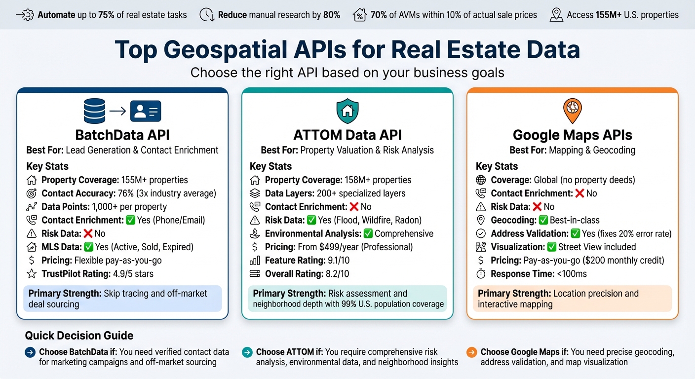
Top Geospatial APIs for Real Estate Data
When it comes to property valuation, geospatial APIs are essential tools for modern real estate technology. Whether you’re focused on property search, skip tracing, or understanding neighborhood dynamics, these APIs offer the foundation for advanced location intelligence.
BatchData API
BatchData provides a wealth of property intelligence and contact enrichment across 155 million properties in the U.S. Known for its expertise in skip tracing, the API delivers phone numbers and email addresses with an accuracy rate of 76%.
Some standout features include property search endpoints, address verification, and bulk data delivery through platforms like S3 and Snowflake. These integrations make it easy to work within modern cloud environments. Additional tools, like reachability scores and litigator scrubs, help marketers and investors connect with property owners while maintaining compliance. Built on a REST architecture, BatchData’s low-latency endpoints are designed to seamlessly integrate with AI and machine learning workflows.
Positioning itself as a modern solution to outdated providers, BatchData focuses on real-time performance and developer-friendly documentation. It’s particularly well-suited for teams managing high-volume marketing campaigns, sourcing off-market deals, or enriching CRM systems at scale.
ATTOM Data API
ATTOM stands out for its extensive property records and neighborhood insights, sourced from tax records, deeds, mortgages, and foreclosure filings. It provides a range of data, including property traits, ownership history, tax assessments, and automated valuation models (AVMs). Specialized datasets for natural hazards and climate exposure are also available, making it a comprehensive tool for property analysis.
ATTOM’s historical data and reliable performance make it a go-to for underwriting, risk assessment, and market analysis. The API offers neighborhood-level insights, such as crime rates, school ratings, and demographic data – key factors for evaluating market trends and property risks. Its natural hazard datasets, which include flood, wildfire, and heat exposure scores, are particularly valuable as climate risk becomes a critical part of due diligence. With pricing starting at $499/year for the professional plan, ATTOM is designed for high-stakes workflows like lending, insurance, and institutional investments.
Google Maps & Geocoding APIs
While BatchData and ATTOM focus on property-specific insights, Google Maps APIs excel in location mapping and visualization. These tools enhance property valuations by offering precise geocoding, address validation, and boundary mapping.
Google Maps APIs enable users to create map-based visualizations of property boundaries, assess proximity to schools and transit, and evaluate walkability. Features like Street View provide added visual context, while the geocoding engine ensures accurate address standardization – a critical capability given that roughly 20% of online addresses contain errors.
Operating on a pay-as-you-go model with a $200 monthly free credit, the Google Maps Platform is accessible for startups and scalable for larger enterprises. Many real estate teams pair Google’s APIs with specialized property data providers, using Google for location mapping and providers like ATTOM and BatchData for detailed property and ownership data. Together, these tools create a complete ecosystem for accurate property valuation.
Comparison of Geospatial API Capabilities
Comparison Table: Features and Benefits
This section outlines the strengths of three leading geospatial APIs, helping users align their property valuation needs with the right platform.
Each API offers distinct advantages for property valuation workflows. ATTOM Data API provides data on 158 million properties, including detailed environmental risk metrics and neighborhood boundaries. BatchData API covers 155 million properties, offering over 1,000 data points for contact enrichment and skip tracing. Meanwhile, Google Maps APIs focus on geospatial mapping and geocoding, but lack property-specific financial data.
Here’s a detailed comparison of their features:
| Feature | BatchData API | ATTOM Data API | Google Maps/Geocoding |
|---|---|---|---|
| Property Count | 155M+ | 158M+ | Global (N/A for deeds) |
| Contact Info | Yes (Phone/Email) | No | No |
| Environmental Risk | No | Yes (Flood, Wildfire, Radon) | No |
| Listing/MLS Data | Yes (Active, Sold, Expired) | Limited | No |
| Valuation Tools | AVM, LTV, ARV | AVM, Comparables, Foreclosure | Geocoding only |
| Integration Options | REST API, Snowflake, S3, Bulk files | REST API, Bulk Data | REST API, JavaScript Library |
| Developer Support | White-glove migration services | Standard technical support | Documentation-heavy self-service |
| Pricing Model | Pay-as-you-go or annual agreements | Professional plan from $499/year | Pay-as-you-go with $200 monthly credit |
| Primary Strength | Lead generation & contact data | Risk assessment & neighborhood depth | Mapping & location precision |
| TrustPilot Rating | 4.9/5 stars | 4.0/5 stars | N/A |
Choosing the Right API for Your Needs
ATTOM Data API is the go-to choice for tasks requiring environmental hazard analysis, school district boundaries, or demographic data, covering 99% of the U.S. population. For example, if you need to assess flood risks or analyze neighborhood trends, ATTOM has you covered.
BatchData API excels in lead generation and contact enrichment, boasting a 76% right-party contact accuracy – three times higher than the industry average. This makes it a powerful tool for off-market deal sourcing and high-volume marketing campaigns.
Google Maps APIs shine when precise geocoding and proximity analytics are needed. Whether you’re creating interactive maps or analyzing location data, Google’s tools provide an essential geospatial layer.
Integration and Pricing Insights
BatchData stands out with its professional migration services, simplifying transitions from legacy systems. ATTOM offers enterprise-grade data solutions but may involve more complex contract negotiations for large-scale use. Google Maps’ pay-as-you-go model, which includes a $200 monthly credit, is particularly appealing for startups and scalable for larger operations.
The best choice depends on your specific goals. If you need comprehensive risk and neighborhood analysis, go with ATTOM. For marketing and lead generation, BatchData is your best bet. And for geospatial mapping and visualization, Google Maps APIs are the ideal fit.
How to Choose the Right Geospatial API
Matching API Features to Your Business Goals
Choosing the right geospatial API starts with understanding your specific business needs. The tools required for off-market deal sourcing are quite different from those needed for property valuation or risk assessment. Begin by identifying your primary workflow, then align it with the features offered by various APIs.
For tasks like investment analytics and property valuation, look for APIs that provide robust Automated Valuation Models (AVMs), detailed sales histories, and accurate market trend forecasts. The ATTOM Data API is a standout in this space, offering over 200 specialized data layers and comparables across more than 155 million U.S. properties. It even boasts a 9.1/10 rating for its features. Other leading APIs also deliver extensive data points and AI-driven forecasting, allowing users to analyze trends from a hyper-local block level to statewide insights.
Different workflows call for different tools. For example:
- Lead generation and off-market sourcing: Look for APIs with contact enrichment and skip tracing capabilities. BatchData’s Real Estate API is a great example, as it appends verified phone numbers and emails to property records, turning a simple address list into actionable leads for direct outreach.
- Geographic targeting: APIs that support polygon and radius searches – beyond the basic ZIP code filters – are essential. ATTOM’s API, for instance, includes ownership history and foreclosure data, which can help refine your targeting efforts.
- Mapping and visualization: Google Maps APIs are ideal for workflows focused on geocoding and interactive mapping. While they don’t provide property-specific financial data, their proximity analytics – like calculating distances to schools or transit – are highly valuable. Many PropTech platforms combine Google Maps’ visualization tools with property data from APIs like ATTOM or BatchData to create user-friendly, client-facing applications.
Evaluating Costs Against API Capabilities
Once you’ve matched API features to your business goals, it’s time to assess their cost-effectiveness. Pricing models vary widely, from pay-as-you-go options to tiered subscriptions and enterprise contracts. For instance, Google Maps offers a pay-per-call model with a $200 monthly free credit, making it a great choice for startups experimenting with integrations. Mid-tier APIs often start at around $70 per month, while enterprise solutions can cost upwards of $499 per month for high-volume usage.
To evaluate ROI, compare the cost per query to the value delivered. An API charging $0.05 per property lookup but offering AVMs, tax data, and neighborhood demographics can save hours of manual research. Accurate valuations alone can increase deal closure rates by 20–30%.
Before committing to a provider, take advantage of free credits or sandbox environments to test the API. Focus on integration complexity, response times (aim for under 100 milliseconds), and data accuracy. Request sample datasets and cross-check them against known properties to ensure the provider’s claims hold up. For example, ATTOM’s overall rating of 8.2/10, with a 6.8/10 score for ease of use, highlights the importance of thorough testing.
If your business has fluctuating query volumes, a pay-as-you-go model can help manage costs with minimal risk. For more established operations, subscription tiers offer predictable monthly expenses. BatchData’s flexible pricing – offering both pay-as-you-go and custom solutions – caters to businesses at various stages of growth. Be sure to account for hidden costs, such as premium features, increased request limits, or migration services, when calculating the total cost of ownership.
Conclusion
Geospatial APIs are transforming how real estate professionals access and use data. Whether you’re leveraging ATTOM’s API to automate valuations for over 155 million U.S. properties, using BatchData to enrich property records with verified contact details, or integrating Google’s geocoding tools to create interactive maps, these tools replace tedious manual research with fast, dependable insights.
The shift to cloud-based integrations has real, measurable benefits. For example, lenders who use nationwide property and hazard data can reduce valuation timelines from days to just minutes, with 70% of automated valuation models (AVMs) falling within 10% of actual sale prices. Similarly, real estate firms employing APIs for tasks like skip tracing and data enrichment can turn basic address lists into actionable leads. These results show that choosing the right API can significantly boost both efficiency and competitiveness.
To make the most of these tools, align API features with your specific needs. ATTOM is an excellent choice for bulk property data, offering detailed tax and ownership records. BatchData specializes in enriched contact details, helping you convert property lists into valuable leads. Meanwhile, Google Maps provides precise geocoding to enhance mapping capabilities. BatchData also stands out with its flexible, pay-as-you-go pricing model, making it scalable for businesses of all sizes.
Testing and thoughtful integration are key to unlocking the full potential of geospatial data. Use sandbox environments and free credits to evaluate data accuracy, response times, and compatibility with your CRM or PropTech platform. In a world where AI-ready APIs and predictive analytics are becoming the norm, these tools don’t just save time – they provide a competitive edge that manual methods simply can’t match.
Define your goals, integrate the right APIs, and build comprehensive property profiles to make smarter decisions and close deals faster. The right approach can turn data into a powerful tool for success.
FAQs
How do I choose a geospatial API for my real estate workflow?
When choosing a geospatial API for real estate, it’s important to weigh a few critical elements: data coverage, features, and integration capabilities. Look for an API that provides reliable property data and supports essential workflows like property enrichment or market analysis. It should also work effortlessly with your existing systems. Additionally, explore geospatial tools that allow for mapping and trend analysis. Don’t overlook scalability and support services to ensure the solution can adapt to your expanding requirements.
What data points matter most for property valuation?
When determining a property’s value, several factors come into play. These include property valuations, market trends, and ownership history, as well as neighborhood analytics. Additionally, physical details like location, property type, and specific features of the property are crucial.
These insights equip real estate professionals with the tools they need to evaluate property values with precision and make well-informed decisions.
How can I test an API’s accuracy and speed before buying?
When deciding whether to invest in an API, it’s smart to test its accuracy and speed first. Performance testing tools, such as Postman, allow you to simulate real-world usage by sending automated requests. This process measures key metrics like response times, throughput, and error rates. By running these tests, you can spot potential bottlenecks and evaluate the API’s reliability, ensuring it aligns with your requirements before making a commitment.